You are here: Home > Network List > TA - USArray Transportable Network (new EarthScope stations) Stations List
> Station Q16A Castle Valley Ranch, Emery, UT, USA > Earthquake Result Viewer
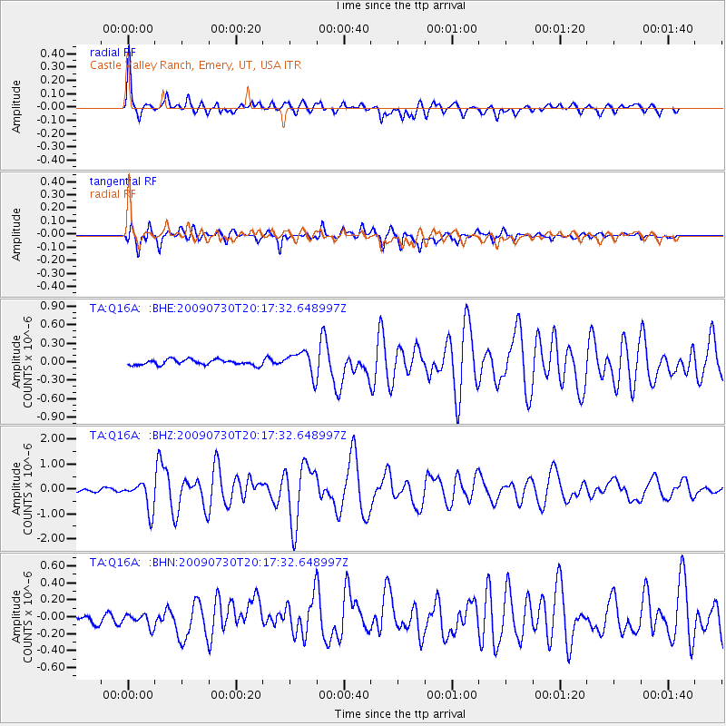
Q16A Castle Valley Ranch, Emery, UT, USA - Earthquake Result Viewer

| Earthquake location: |
Tonga Islands |
| Earthquake latitude/longitude: |
-20.8/-174.3 |
| Earthquake time(UTC): |
2009/07/30 (211) 20:05:34 GMT |
| Earthquake Depth: |
10 km |
| Earthquake Magnitude: |
5.9 MB, 5.7 MS, 5.8 MW, 5.7 MW |
| Earthquake Catalog/Contributor: |
WHDF/NEIC |
|
| Network: |
TA USArray Transportable Network (new EarthScope stations) |
| Station: |
Q16A Castle Valley Ranch, Emery, UT, USA |
| Lat/Lon: |
38.92 N/111.17 W |
| Elevation: |
1912 m |
|
| Distance: |
83.7 deg |
| Az: |
44.407 deg |
| Baz: |
237.032 deg |
| Ray Param: |
0.04597028 |
| Estimated Moho Depth: |
63.0 km |
| Estimated Crust Vp/Vs: |
1.70 |
| Assumed Crust Vp: |
6.207 km/s |
| Estimated Crust Vs: |
3.656 km/s |
| Estimated Crust Poisson's Ratio: |
0.23 |
|
| Radial Match: |
91.27304 % |
| Radial Bump: |
400 |
| Transverse Match: |
89.70599 % |
| Transverse Bump: |
400 |
| SOD ConfigId: |
2622 |
| Insert Time: |
2010-03-06 05:47:11.560 +0000 |
| GWidth: |
2.5 |
| Max Bumps: |
400 |
| Tol: |
0.001 |
|
Signal To Noise
| Channel | StoN | STA | LTA |
| TA:Q16A: :BHZ:20090730T20:17:32.648997Z | 10.828211 | 5.8251334E-7 | 5.3795905E-8 |
| TA:Q16A: :BHN:20090730T20:17:32.648997Z | 1.5435704 | 8.500839E-8 | 5.5072572E-8 |
| TA:Q16A: :BHE:20090730T20:17:32.648997Z | 4.344251 | 1.9009897E-7 | 4.3758742E-8 |
| Arrivals |
| Ps | 7.3 SECOND |
| PpPs | 27 SECOND |
| PsPs/PpSs | 34 SECOND |


