You are here: Home > Network List > AK - Alaska Regional Network Stations List
> Station BAGL Bagley Icefield, AK, USA > Earthquake Result Viewer
BAGL Bagley Icefield, AK, USA - Earthquake Result Viewer
| Earthquake location: |
Loyalty Islands |
| Earthquake latitude/longitude: |
-21.6/168.9 |
| Earthquake time(UTC): |
2017/11/01 (305) 02:23:56 GMT |
| Earthquake Depth: |
10 km |
| Earthquake Magnitude: |
6.6 mww |
| Earthquake Catalog/Contributor: |
NEIC PDE/us |
|
| Network: |
AK Alaska Regional Network |
| Station: |
BAGL Bagley Icefield, AK, USA |
| Lat/Lon: |
60.49 N/142.09 W |
| Elevation: |
1470 m |
|
| Distance: |
90.9 deg |
| Az: |
21.953 deg |
| Baz: |
224.633 deg |
| Ray Param: |
0.041637782 |
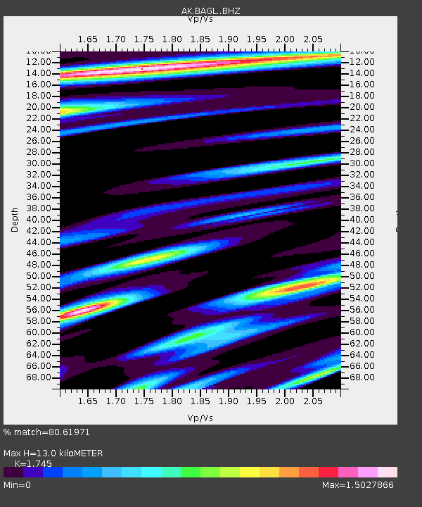
| Estimated Moho Depth: |
13.0 km |
| Estimated Crust Vp/Vs: |
1.75 |
| Assumed Crust Vp: |
6.566 km/s |
| Estimated Crust Vs: |
3.763 km/s |
| Estimated Crust Poisson's Ratio: |
0.26 |
|
| Radial Match: |
80.61971 % |
| Radial Bump: |
400 |
| Transverse Match: |
57.561924 % |
| Transverse Bump: |
400 |
| SOD ConfigId: |
13570011 |
| Insert Time: |
2019-04-29 01:59:38.835 +0000 |
| GWidth: |
2.5 |
| Max Bumps: |
400 |
| Tol: |
0.001 |
|

Signal To Noise
| Channel | StoN | STA | LTA |
| AK:BAGL: :BHZ:20171101T02:36:28.34802Z | 1.2776963 | 4.875488E-7 | 3.8158424E-7 |
| AK:BAGL: :BHN:20171101T02:36:28.34802Z | 0.8899649 | 4.032633E-7 | 4.531227E-7 |
| AK:BAGL: :BHE:20171101T02:36:28.34802Z | 1.4838376 | 4.6347364E-7 | 3.1234796E-7 |
| Arrivals |
| Ps | 1.5 SECOND |
| PpPs | 5.3 SECOND |
| PsPs/PpSs | 6.8 SECOND |


