You are here: Home > Network List > US - United States National Seismic Network Stations List
> Station AGMN Agassiz National Wildlife Refuge, Minnesota, USA > Earthquake Result Viewer
AGMN Agassiz National Wildlife Refuge, Minnesota, USA - Earthquake Result Viewer
*The percent match for this event was below the threshold and hence no stack was calculated.
| Earthquake location: |
Leeward Islands |
| Earthquake latitude/longitude: |
18.0/-60.7 |
| Earthquake time(UTC): |
2016/03/19 (079) 11:26:34 GMT |
| Earthquake Depth: |
32 km |
| Earthquake Magnitude: |
6.0 MWW, 5.9 MWB |
| Earthquake Catalog/Contributor: |
NEIC PDE/NEIC COMCAT |
|
| Network: |
US United States National Seismic Network |
| Station: |
AGMN Agassiz National Wildlife Refuge, Minnesota, USA |
| Lat/Lon: |
48.30 N/95.86 W |
| Elevation: |
351 m |
|
| Distance: |
41.6 deg |
| Az: |
324.587 deg |
| Baz: |
124.321 deg |
| Ray Param: |
$rayparam |
*The percent match for this event was below the threshold and hence was not used in the summary stack. |
|
| Radial Match: |
78.6021 % |
| Radial Bump: |
358 |
| Transverse Match: |
56.24201 % |
| Transverse Bump: |
400 |
| SOD ConfigId: |
1475611 |
| Insert Time: |
2016-04-11 16:01:27.158 +0000 |
| GWidth: |
2.5 |
| Max Bumps: |
400 |
| Tol: |
0.001 |
|
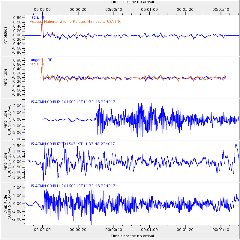
Signal To Noise
| Channel | StoN | STA | LTA |
| US:AGMN:00:BHZ:20160319T11:33:48.22401Z | 5.6806426 | 7.6887767E-7 | 1.3535048E-7 |
| US:AGMN:00:BH1:20160319T11:33:48.22401Z | 5.2797713 | 8.61608E-7 | 1.6319039E-7 |
| US:AGMN:00:BH2:20160319T11:33:48.22401Z | 9.566479 | 1.14204E-6 | 1.1937935E-7 |
| Arrivals |
| Ps | |
| PpPs | |
| PsPs/PpSs | |


