You are here: Home > Network List > US - United States National Seismic Network Stations List
> Station DGMT Dagmar, Montana, USA > Earthquake Result Viewer
DGMT Dagmar, Montana, USA - Earthquake Result Viewer
*The percent match for this event was below the threshold and hence no stack was calculated.
| Earthquake location: |
Leeward Islands |
| Earthquake latitude/longitude: |
18.0/-60.7 |
| Earthquake time(UTC): |
2016/03/19 (079) 11:26:34 GMT |
| Earthquake Depth: |
32 km |
| Earthquake Magnitude: |
6.0 MWW, 5.9 MWB |
| Earthquake Catalog/Contributor: |
NEIC PDE/NEIC COMCAT |
|
| Network: |
US United States National Seismic Network |
| Station: |
DGMT Dagmar, Montana, USA |
| Lat/Lon: |
48.47 N/104.20 W |
| Elevation: |
0.0 m |
|
| Distance: |
46.5 deg |
| Az: |
320.825 deg |
| Baz: |
115.397 deg |
| Ray Param: |
$rayparam |
*The percent match for this event was below the threshold and hence was not used in the summary stack. |
|
| Radial Match: |
48.74815 % |
| Radial Bump: |
400 |
| Transverse Match: |
46.298763 % |
| Transverse Bump: |
334 |
| SOD ConfigId: |
1475611 |
| Insert Time: |
2016-04-11 16:01:35.506 +0000 |
| GWidth: |
2.5 |
| Max Bumps: |
400 |
| Tol: |
0.001 |
|
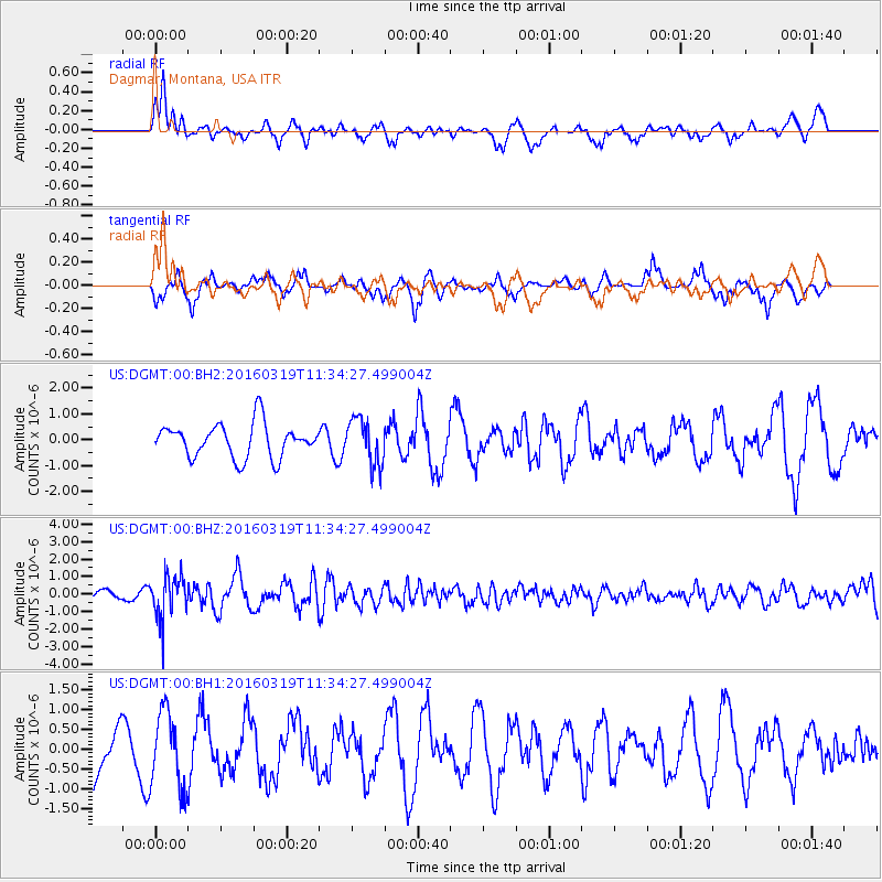
Signal To Noise
| Channel | StoN | STA | LTA |
| US:DGMT:00:BHZ:20160319T11:34:27.499004Z | 4.7489166 | 1.2538867E-6 | 2.6403634E-7 |
| US:DGMT:00:BH1:20160319T11:34:27.499004Z | 1.1995031 | 9.522023E-7 | 7.938307E-7 |
| US:DGMT:00:BH2:20160319T11:34:27.499004Z | 1.3625689 | 8.873571E-7 | 6.5123834E-7 |
| Arrivals |
| Ps | |
| PpPs | |
| PsPs/PpSs | |


