You are here: Home > Network List > TA - USArray Transportable Network (new EarthScope stations) Stations List
> Station H16K Elim, AK, USA > Earthquake Result Viewer
H16K Elim, AK, USA - Earthquake Result Viewer
| Earthquake location: |
Loyalty Islands |
| Earthquake latitude/longitude: |
-21.6/168.9 |
| Earthquake time(UTC): |
2017/11/01 (305) 02:23:56 GMT |
| Earthquake Depth: |
10 km |
| Earthquake Magnitude: |
6.6 mww |
| Earthquake Catalog/Contributor: |
NEIC PDE/us |
|
| Network: |
TA USArray Transportable Network (new EarthScope stations) |
| Station: |
H16K Elim, AK, USA |
| Lat/Lon: |
64.64 N/162.24 W |
| Elevation: |
216 m |
|
| Distance: |
88.8 deg |
| Az: |
12.007 deg |
| Baz: |
206.707 deg |
| Ray Param: |
0.042282533 |
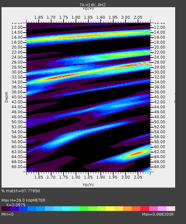
| Estimated Moho Depth: |
26.0 km |
| Estimated Crust Vp/Vs: |
2.10 |
| Assumed Crust Vp: |
6.276 km/s |
| Estimated Crust Vs: |
2.992 km/s |
| Estimated Crust Poisson's Ratio: |
0.35 |
|
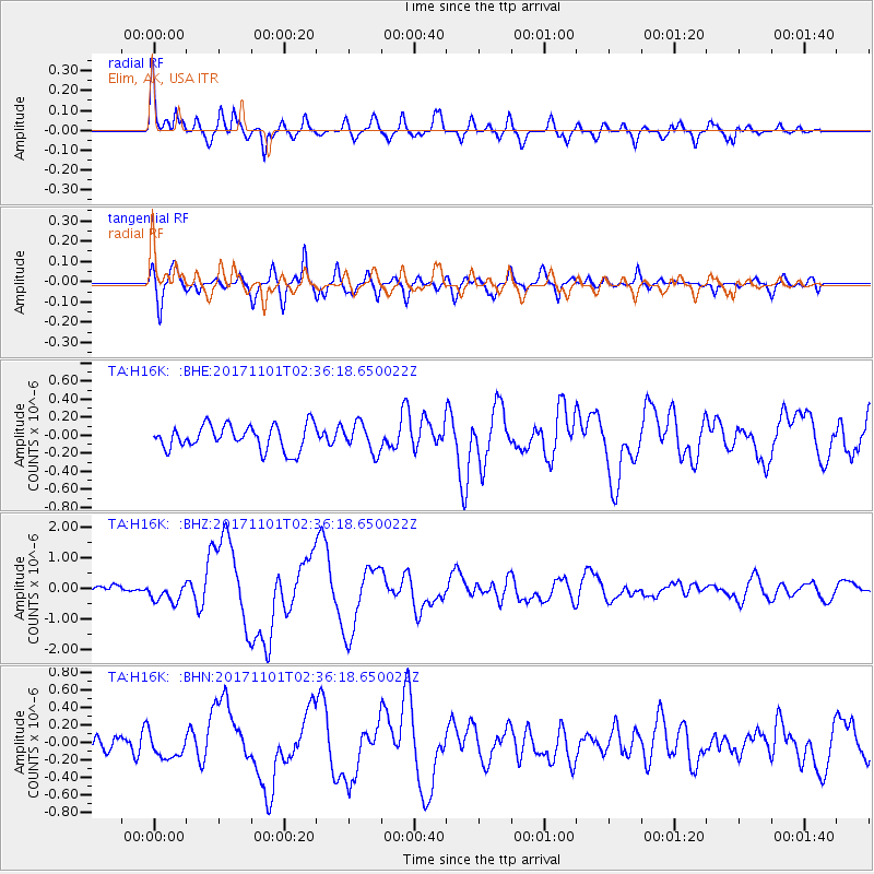
| Radial Match: |
87.77858 % |
| Radial Bump: |
400 |
| Transverse Match: |
74.16147 % |
| Transverse Bump: |
400 |
| SOD ConfigId: |
13570011 |
| Insert Time: |
2019-04-29 02:02:55.548 +0000 |
| GWidth: |
2.5 |
| Max Bumps: |
400 |
| Tol: |
0.001 |
|
Signal To Noise
| Channel | StoN | STA | LTA |
| TA:H16K: :BHZ:20171101T02:36:18.650022Z | 2.8246663 | 3.143653E-7 | 1.112929E-7 |
| TA:H16K: :BHN:20171101T02:36:18.650022Z | 1.205825 | 1.364426E-7 | 1.1315291E-7 |
| TA:H16K: :BHE:20171101T02:36:18.650022Z | 1.1373302 | 1.5649145E-7 | 1.3759545E-7 |
| Arrivals |
| Ps | 4.6 SECOND |
| PpPs | 13 SECOND |
| PsPs/PpSs | 17 SECOND |


