You are here: Home > Network List > TA - USArray Transportable Network (new EarthScope stations) Stations List
> Station L15K Ungalak Mountain, AK, USA > Earthquake Result Viewer
L15K Ungalak Mountain, AK, USA - Earthquake Result Viewer
| Earthquake location: |
Loyalty Islands |
| Earthquake latitude/longitude: |
-21.6/168.9 |
| Earthquake time(UTC): |
2017/11/01 (305) 02:23:56 GMT |
| Earthquake Depth: |
10 km |
| Earthquake Magnitude: |
6.6 mww |
| Earthquake Catalog/Contributor: |
NEIC PDE/us |
|
| Network: |
TA USArray Transportable Network (new EarthScope stations) |
| Station: |
L15K Ungalak Mountain, AK, USA |
| Lat/Lon: |
61.68 N/161.49 W |
| Elevation: |
219 m |
|
| Distance: |
86.4 deg |
| Az: |
13.665 deg |
| Baz: |
207.447 deg |
| Ray Param: |
0.044111077 |
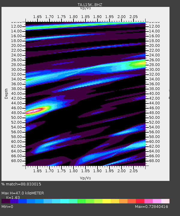
| Estimated Moho Depth: |
47.0 km |
| Estimated Crust Vp/Vs: |
1.63 |
| Assumed Crust Vp: |
6.182 km/s |
| Estimated Crust Vs: |
3.793 km/s |
| Estimated Crust Poisson's Ratio: |
0.20 |
|
| Radial Match: |
88.833015 % |
| Radial Bump: |
373 |
| Transverse Match: |
81.29106 % |
| Transverse Bump: |
400 |
| SOD ConfigId: |
13570011 |
| Insert Time: |
2019-04-29 02:03:06.183 +0000 |
| GWidth: |
2.5 |
| Max Bumps: |
400 |
| Tol: |
0.001 |
|

Signal To Noise
| Channel | StoN | STA | LTA |
| TA:L15K: :BHZ:20171101T02:36:06.70001Z | 2.9234898 | 3.8940186E-7 | 1.331976E-7 |
| TA:L15K: :BHN:20171101T02:36:06.70001Z | 0.7056608 | 9.408042E-8 | 1.3332243E-7 |
| TA:L15K: :BHE:20171101T02:36:06.70001Z | 1.2319248 | 1.364589E-7 | 1.10768845E-7 |
| Arrivals |
| Ps | 4.9 SECOND |
| PpPs | 20 SECOND |
| PsPs/PpSs | 24 SECOND |


