You are here: Home > Network List > TA - USArray Transportable Network (new EarthScope stations) Stations List
> Station Q16A Castle Valley Ranch, Emery, UT, USA > Earthquake Result Viewer
Q16A Castle Valley Ranch, Emery, UT, USA - Earthquake Result Viewer
| Earthquake location: |
Near Coast Of Northern Chile |
| Earthquake latitude/longitude: |
-23.1/-70.6 |
| Earthquake time(UTC): |
2007/11/17 (321) 17:54:32 GMT |
| Earthquake Depth: |
15 km |
| Earthquake Magnitude: |
5.6 MB, 5.6 MS, 5.8 MW, 5.8 MW |
| Earthquake Catalog/Contributor: |
WHDF/NEIC |
|
| Network: |
TA USArray Transportable Network (new EarthScope stations) |
| Station: |
Q16A Castle Valley Ranch, Emery, UT, USA |
| Lat/Lon: |
38.92 N/111.17 W |
| Elevation: |
1912 m |
|
| Distance: |
72.4 deg |
| Az: |
327.841 deg |
| Baz: |
141.065 deg |
| Ray Param: |
0.05366518 |
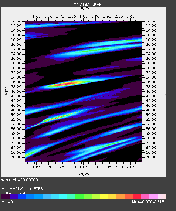
| Estimated Moho Depth: |
51.0 km |
| Estimated Crust Vp/Vs: |
1.74 |
| Assumed Crust Vp: |
6.207 km/s |
| Estimated Crust Vs: |
3.572 km/s |
| Estimated Crust Poisson's Ratio: |
0.25 |
|
| Radial Match: |
80.03209 % |
| Radial Bump: |
389 |
| Transverse Match: |
54.132584 % |
| Transverse Bump: |
355 |
| SOD ConfigId: |
2564 |
| Insert Time: |
2010-03-06 05:48:02.327 +0000 |
| GWidth: |
2.5 |
| Max Bumps: |
400 |
| Tol: |
0.001 |
|
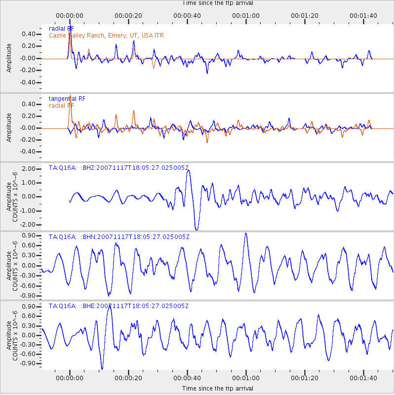
Signal To Noise
| Channel | StoN | STA | LTA |
| TA:Q16A: :BHN:20071117T18:05:27.025005Z | 2.810825 | 3.9917091E-7 | 1.4201201E-7 |
| TA:Q16A: :BHE:20071117T18:05:27.025005Z | 0.731281 | 1.5894963E-7 | 2.1735782E-7 |
| TA:Q16A: :BHZ:20071117T18:05:27.025005Z | 1.5191612 | 3.1849947E-7 | 2.0965483E-7 |
| Arrivals |
| Ps | 6.3 SECOND |
| PpPs | 22 SECOND |
| PsPs/PpSs | 28 SECOND |


