You are here: Home > Network List > TA - USArray Transportable Network (new EarthScope stations) Stations List
> Station P18K Big Mountain, AK, USA > Earthquake Result Viewer
P18K Big Mountain, AK, USA - Earthquake Result Viewer
| Earthquake location: |
Loyalty Islands |
| Earthquake latitude/longitude: |
-21.6/168.9 |
| Earthquake time(UTC): |
2017/11/01 (305) 02:23:56 GMT |
| Earthquake Depth: |
10 km |
| Earthquake Magnitude: |
6.6 mww |
| Earthquake Catalog/Contributor: |
NEIC PDE/us |
|
| Network: |
TA USArray Transportable Network (new EarthScope stations) |
| Station: |
P18K Big Mountain, AK, USA |
| Lat/Lon: |
59.39 N/155.23 W |
| Elevation: |
680 m |
|
| Distance: |
85.9 deg |
| Az: |
17.5 deg |
| Baz: |
213.147 deg |
| Ray Param: |
0.044407353 |
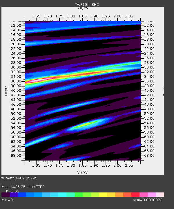
| Estimated Moho Depth: |
35.25 km |
| Estimated Crust Vp/Vs: |
1.66 |
| Assumed Crust Vp: |
6.438 km/s |
| Estimated Crust Vs: |
3.878 km/s |
| Estimated Crust Poisson's Ratio: |
0.22 |
|
| Radial Match: |
89.05795 % |
| Radial Bump: |
381 |
| Transverse Match: |
64.64649 % |
| Transverse Bump: |
400 |
| SOD ConfigId: |
13570011 |
| Insert Time: |
2019-04-29 02:03:20.952 +0000 |
| GWidth: |
2.5 |
| Max Bumps: |
400 |
| Tol: |
0.001 |
|

Signal To Noise
| Channel | StoN | STA | LTA |
| TA:P18K: :BHZ:20171101T02:36:04.650022Z | 3.009014 | 5.154869E-7 | 1.7131421E-7 |
| TA:P18K: :BHN:20171101T02:36:04.650022Z | 0.72769785 | 1.6877114E-7 | 2.3192474E-7 |
| TA:P18K: :BHE:20171101T02:36:04.650022Z | 0.63067937 | 1.1352136E-7 | 1.7999854E-7 |
| Arrivals |
| Ps | 3.7 SECOND |
| PpPs | 14 SECOND |
| PsPs/PpSs | 18 SECOND |


