You are here: Home > Network List > UW - Pacific Northwest Regional Seismic Network Stations List
> Station YACT Amboy, WA, USA > Earthquake Result Viewer
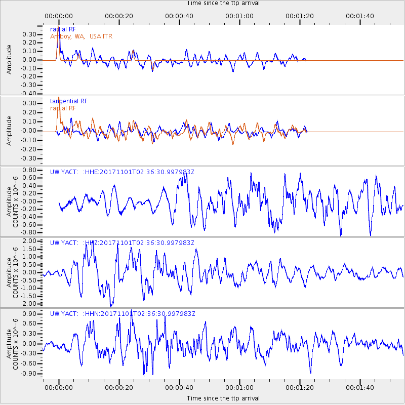
YACT Amboy, WA, USA - Earthquake Result Viewer
*The percent match for this event was below the threshold and hence no stack was calculated.
| Earthquake location: |
Loyalty Islands |
| Earthquake latitude/longitude: |
-21.6/168.9 |
| Earthquake time(UTC): |
2017/11/01 (305) 02:23:56 GMT |
| Earthquake Depth: |
10 km |
| Earthquake Magnitude: |
6.6 mww |
| Earthquake Catalog/Contributor: |
NEIC PDE/us |
|
| Network: |
UW Pacific Northwest Regional Seismic Network |
| Station: |
YACT Amboy, WA, USA |
| Lat/Lon: |
45.93 N/122.42 W |
| Elevation: |
211 m |
|
| Distance: |
91.5 deg |
| Az: |
40.576 deg |
| Baz: |
240.13 deg |
| Ray Param: |
$rayparam |
*The percent match for this event was below the threshold and hence was not used in the summary stack. |
|
| Radial Match: |
79.44377 % |
| Radial Bump: |
400 |
| Transverse Match: |
65.12032 % |
| Transverse Bump: |
400 |
| SOD ConfigId: |
13570011 |
| Insert Time: |
2019-04-29 02:04:00.421 +0000 |
| GWidth: |
2.5 |
| Max Bumps: |
400 |
| Tol: |
0.001 |
|
Signal To Noise
| Channel | StoN | STA | LTA |
| UW:YACT: :HHZ:20171101T02:36:30.997983Z | 1.8754443 | 3.7985006E-7 | 2.025387E-7 |
| UW:YACT: :HHN:20171101T02:36:30.997983Z | 0.9499311 | 1.2748241E-7 | 1.3420174E-7 |
| UW:YACT: :HHE:20171101T02:36:30.997983Z | 1.1322598 | 1.9243369E-7 | 1.699554E-7 |
| Arrivals |
| Ps | |
| PpPs | |
| PsPs/PpSs | |


