You are here: Home > Network List > YT07 - POLENET Stations List
> Station P061 P061 > Earthquake Result Viewer
P061 P061 - Earthquake Result Viewer
| Earthquake location: |
Loyalty Islands |
| Earthquake latitude/longitude: |
-21.6/168.9 |
| Earthquake time(UTC): |
2017/11/01 (305) 02:23:56 GMT |
| Earthquake Depth: |
10 km |
| Earthquake Magnitude: |
6.6 mww |
| Earthquake Catalog/Contributor: |
NEIC PDE/us |
|
| Network: |
YT POLENET |
| Station: |
P061 P061 |
| Lat/Lon: |
84.50 S/77.22 E |
| Elevation: |
1758 m |
|
| Distance: |
68.8 deg |
| Az: |
185.939 deg |
| Baz: |
93.825 deg |
| Ray Param: |
0.056088913 |
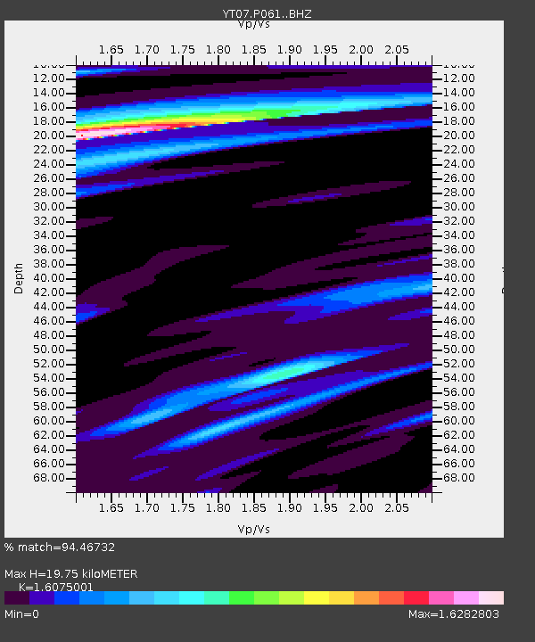
| Estimated Moho Depth: |
19.75 km |
| Estimated Crust Vp/Vs: |
1.61 |
| Assumed Crust Vp: |
6.261 km/s |
| Estimated Crust Vs: |
3.895 km/s |
| Estimated Crust Poisson's Ratio: |
0.18 |
|
| Radial Match: |
94.46732 % |
| Radial Bump: |
400 |
| Transverse Match: |
90.37833 % |
| Transverse Bump: |
400 |
| SOD ConfigId: |
13570011 |
| Insert Time: |
2019-04-29 02:04:23.888 +0000 |
| GWidth: |
2.5 |
| Max Bumps: |
400 |
| Tol: |
0.001 |
|

Signal To Noise
| Channel | StoN | STA | LTA |
| YT:P061: :BHZ:20171101T02:34:28.424985Z | 4.036599 | 6.4558037E-7 | 1.5993174E-7 |
| YT:P061: :BHN:20171101T02:34:28.424985Z | 0.949651 | 7.223728E-8 | 7.606719E-8 |
| YT:P061: :BHE:20171101T02:34:28.424985Z | 1.4421091 | 1.4576904E-7 | 1.0108045E-7 |
| Arrivals |
| Ps | 2.0 SECOND |
| PpPs | 7.9 SECOND |
| PsPs/PpSs | 9.9 SECOND |


