You are here: Home > Network List > YT07 - POLENET Stations List
> Station WAWA WAWA > Earthquake Result Viewer
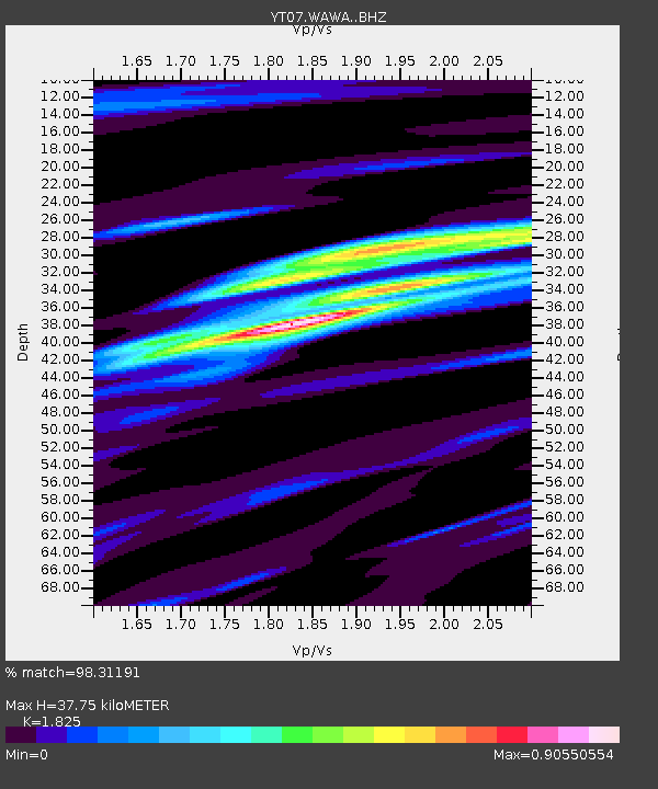
WAWA WAWA - Earthquake Result Viewer
| Earthquake location: |
Loyalty Islands |
| Earthquake latitude/longitude: |
-21.6/168.9 |
| Earthquake time(UTC): |
2017/11/01 (305) 02:23:56 GMT |
| Earthquake Depth: |
10 km |
| Earthquake Magnitude: |
6.6 mww |
| Earthquake Catalog/Contributor: |
NEIC PDE/us |
|
| Network: |
YT POLENET |
| Station: |
WAWA WAWA |
| Lat/Lon: |
81.58 S/28.42 W |
| Elevation: |
1202 m |
|
| Distance: |
76.6 deg |
| Az: |
177.417 deg |
| Baz: |
196.528 deg |
| Ray Param: |
0.05087635 |
| Estimated Moho Depth: |
37.75 km |
| Estimated Crust Vp/Vs: |
1.83 |
| Assumed Crust Vp: |
6.424 km/s |
| Estimated Crust Vs: |
3.52 km/s |
| Estimated Crust Poisson's Ratio: |
0.29 |
|
| Radial Match: |
98.31191 % |
| Radial Bump: |
332 |
| Transverse Match: |
96.18102 % |
| Transverse Bump: |
400 |
| SOD ConfigId: |
13570011 |
| Insert Time: |
2019-04-29 02:04:31.484 +0000 |
| GWidth: |
2.5 |
| Max Bumps: |
400 |
| Tol: |
0.001 |
|

Signal To Noise
| Channel | StoN | STA | LTA |
| YT:WAWA: :BHZ:20171101T02:35:14.95001Z | 12.90048 | 1.012252E-6 | 7.846622E-8 |
| YT:WAWA: :BHN:20171101T02:35:14.95001Z | 4.291245 | 3.220582E-7 | 7.505006E-8 |
| YT:WAWA: :BHE:20171101T02:35:14.95001Z | 2.4089284 | 1.8139062E-7 | 7.52993E-8 |
| Arrivals |
| Ps | 5.0 SECOND |
| PpPs | 16 SECOND |
| PsPs/PpSs | 21 SECOND |


