You are here: Home > Network List > TA - USArray Transportable Network (new EarthScope stations) Stations List
> Station Q16A Castle Valley Ranch, Emery, UT, USA > Earthquake Result Viewer
Q16A Castle Valley Ranch, Emery, UT, USA - Earthquake Result Viewer
| Earthquake location: |
Vanuatu Islands |
| Earthquake latitude/longitude: |
-15.6/167.7 |
| Earthquake time(UTC): |
2007/08/01 (213) 17:08:51 GMT |
| Earthquake Depth: |
120 km |
| Earthquake Magnitude: |
6.2 MB, 7.2 MW, 7.2 MW |
| Earthquake Catalog/Contributor: |
WHDF/NEIC |
|
| Network: |
TA USArray Transportable Network (new EarthScope stations) |
| Station: |
Q16A Castle Valley Ranch, Emery, UT, USA |
| Lat/Lon: |
38.92 N/111.17 W |
| Elevation: |
1912 m |
|
| Distance: |
93.0 deg |
| Az: |
50.519 deg |
| Baz: |
252.447 deg |
| Ray Param: |
0.04129056 |
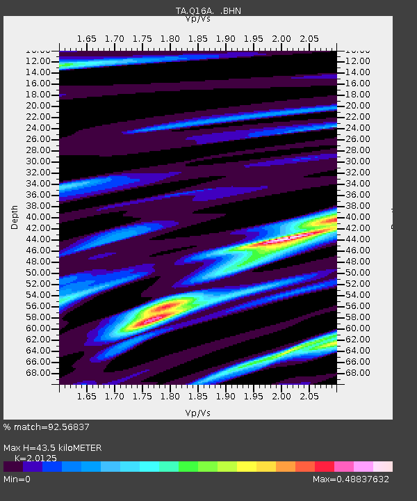
| Estimated Moho Depth: |
43.5 km |
| Estimated Crust Vp/Vs: |
2.01 |
| Assumed Crust Vp: |
6.207 km/s |
| Estimated Crust Vs: |
3.084 km/s |
| Estimated Crust Poisson's Ratio: |
0.34 |
|
| Radial Match: |
92.56837 % |
| Radial Bump: |
364 |
| Transverse Match: |
85.64522 % |
| Transverse Bump: |
400 |
| SOD ConfigId: |
2564 |
| Insert Time: |
2010-03-06 05:48:32.485 +0000 |
| GWidth: |
2.5 |
| Max Bumps: |
400 |
| Tol: |
0.001 |
|

Signal To Noise
| Channel | StoN | STA | LTA |
| TA:Q16A: :BHN:20070801T17:21:19.748022Z | 1.0550307 | 5.846022E-8 | 5.5410915E-8 |
| TA:Q16A: :BHE:20070801T17:21:19.748022Z | 1.5121075 | 9.9069425E-8 | 6.551745E-8 |
| TA:Q16A: :BHZ:20070801T17:21:19.748022Z | 3.3740304 | 2.9881184E-7 | 8.856229E-8 |
| Arrivals |
| Ps | 7.2 SECOND |
| PpPs | 21 SECOND |
| PsPs/PpSs | 28 SECOND |


