You are here: Home > Network List > TA - USArray Transportable Network (new EarthScope stations) Stations List
> Station Q16A Castle Valley Ranch, Emery, UT, USA > Earthquake Result Viewer
Q16A Castle Valley Ranch, Emery, UT, USA - Earthquake Result Viewer
| Earthquake location: |
South Of Panama |
| Earthquake latitude/longitude: |
5.7/-82.8 |
| Earthquake time(UTC): |
2009/03/12 (071) 23:23:34 GMT |
| Earthquake Depth: |
9.0 km |
| Earthquake Magnitude: |
6.1 MB, 5.9 MS, 6.3 MW, 6.2 MW |
| Earthquake Catalog/Contributor: |
WHDF/NEIC |
|
| Network: |
TA USArray Transportable Network (new EarthScope stations) |
| Station: |
Q16A Castle Valley Ranch, Emery, UT, USA |
| Lat/Lon: |
38.92 N/111.17 W |
| Elevation: |
1912 m |
|
| Distance: |
41.9 deg |
| Az: |
326.235 deg |
| Baz: |
134.848 deg |
| Ray Param: |
0.07350796 |
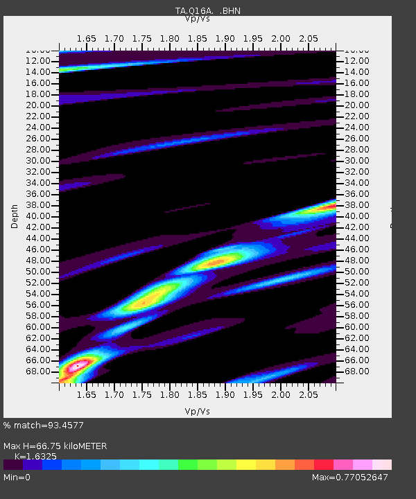
| Estimated Moho Depth: |
66.75 km |
| Estimated Crust Vp/Vs: |
1.63 |
| Assumed Crust Vp: |
6.207 km/s |
| Estimated Crust Vs: |
3.802 km/s |
| Estimated Crust Poisson's Ratio: |
0.20 |
|
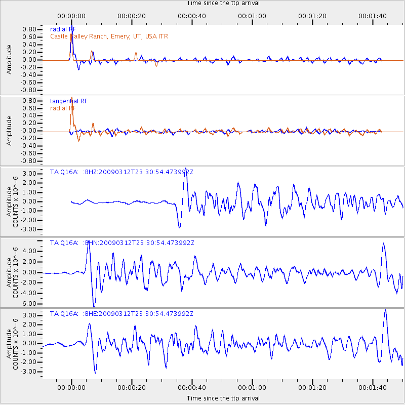
| Radial Match: |
93.4577 % |
| Radial Bump: |
303 |
| Transverse Match: |
69.53966 % |
| Transverse Bump: |
400 |
| SOD ConfigId: |
2658 |
| Insert Time: |
2010-03-06 05:49:12.866 +0000 |
| GWidth: |
2.5 |
| Max Bumps: |
400 |
| Tol: |
0.001 |
|
Signal To Noise
| Channel | StoN | STA | LTA |
| TA:Q16A: :BHN:20090312T23:30:54.473992Z | 2.753747 | 3.7380732E-7 | 1.3574498E-7 |
| TA:Q16A: :BHE:20090312T23:30:54.473992Z | 1.2545723 | 1.843262E-7 | 1.4692354E-7 |
| TA:Q16A: :BHZ:20090312T23:30:54.473992Z | 1.6428903 | 1.734807E-7 | 1.0559481E-7 |
| Arrivals |
| Ps | 7.3 SECOND |
| PpPs | 26 SECOND |
| PsPs/PpSs | 34 SECOND |


