You are here: Home > Network List > TA - USArray Transportable Network (new EarthScope stations) Stations List
> Station Q16A Castle Valley Ranch, Emery, UT, USA > Earthquake Result Viewer
Q16A Castle Valley Ranch, Emery, UT, USA - Earthquake Result Viewer
| Earthquake location: |
Tonga Islands Region |
| Earthquake latitude/longitude: |
-23.0/-174.7 |
| Earthquake time(UTC): |
2009/03/19 (078) 18:17:40 GMT |
| Earthquake Depth: |
34 km |
| Earthquake Magnitude: |
7.0 MB, 7.6 MS, 7.6 MW, 7.6 MW |
| Earthquake Catalog/Contributor: |
WHDF/NEIC |
|
| Network: |
TA USArray Transportable Network (new EarthScope stations) |
| Station: |
Q16A Castle Valley Ranch, Emery, UT, USA |
| Lat/Lon: |
38.92 N/111.17 W |
| Elevation: |
1912 m |
|
| Distance: |
85.6 deg |
| Az: |
44.44 deg |
| Baz: |
235.765 deg |
| Ray Param: |
0.044624638 |
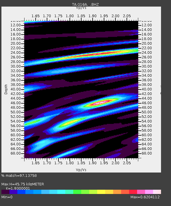
| Estimated Moho Depth: |
45.75 km |
| Estimated Crust Vp/Vs: |
1.93 |
| Assumed Crust Vp: |
6.207 km/s |
| Estimated Crust Vs: |
3.216 km/s |
| Estimated Crust Poisson's Ratio: |
0.32 |
|
| Radial Match: |
97.13758 % |
| Radial Bump: |
400 |
| Transverse Match: |
91.20704 % |
| Transverse Bump: |
400 |
| SOD ConfigId: |
2658 |
| Insert Time: |
2010-03-06 05:49:21.593 +0000 |
| GWidth: |
2.5 |
| Max Bumps: |
400 |
| Tol: |
0.001 |
|

Signal To Noise
| Channel | StoN | STA | LTA |
| TA:Q16A: :BHZ:20090319T18:29:44.475002Z | 21.230602 | 5.922999E-6 | 2.7898406E-7 |
| TA:Q16A: :BHN:20090319T18:29:44.475002Z | 11.257209 | 9.0433406E-7 | 8.033377E-8 |
| TA:Q16A: :BHE:20090319T18:29:44.475002Z | 6.290705 | 1.1633454E-6 | 1.8493084E-7 |
| Arrivals |
| Ps | 7.0 SECOND |
| PpPs | 21 SECOND |
| PsPs/PpSs | 28 SECOND |


