You are here: Home > Network List > TA - USArray Transportable Network (new EarthScope stations) Stations List
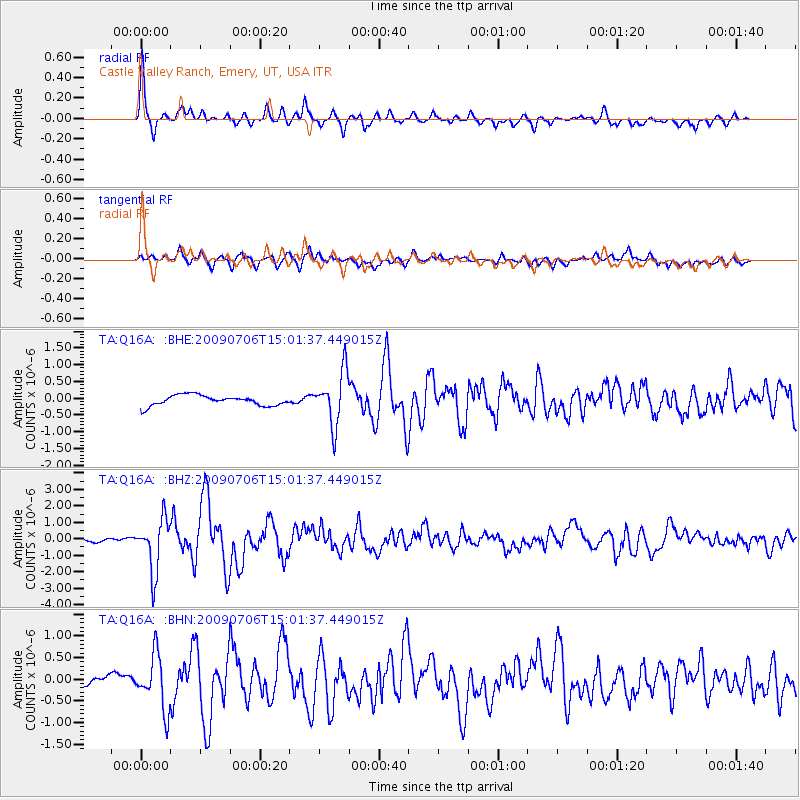
> Station Q16A Castle Valley Ranch, Emery, UT, USA > Earthquake Result Viewer
Q16A Castle Valley Ranch, Emery, UT, USA - Earthquake Result Viewer
| Earthquake location: |
Rat Islands, Aleutian Islands |
| Earthquake latitude/longitude: |
50.4/177.0 |
| Earthquake time(UTC): |
2009/07/06 (187) 14:53:12 GMT |
| Earthquake Depth: |
22 km |
| Earthquake Magnitude: |
6.0 MB, 5.8 MS, 6.1 MW, 6.0 MW |
| Earthquake Catalog/Contributor: |
WHDF/NEIC |
|
| Network: |
TA USArray Transportable Network (new EarthScope stations) |
| Station: |
Q16A Castle Valley Ranch, Emery, UT, USA |
| Lat/Lon: |
38.92 N/111.17 W |
| Elevation: |
1912 m |
|
| Distance: |
50.5 deg |
| Az: |
73.958 deg |
| Baz: |
308.017 deg |
| Ray Param: |
0.06800517 |
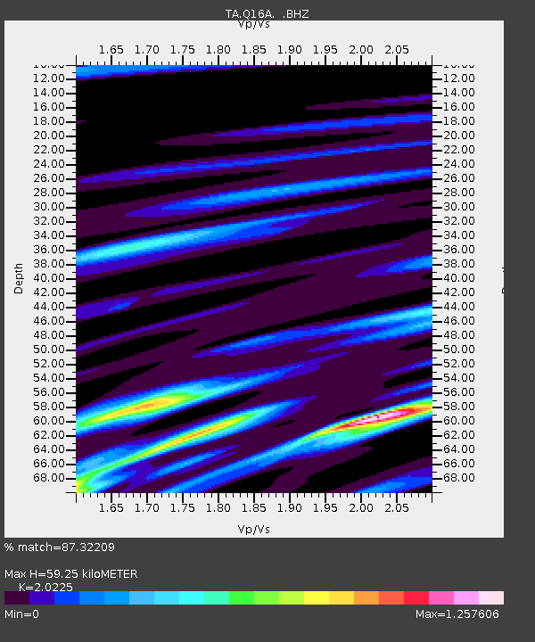
| Estimated Moho Depth: |
59.25 km |
| Estimated Crust Vp/Vs: |
2.02 |
| Assumed Crust Vp: |
6.207 km/s |
| Estimated Crust Vs: |
3.069 km/s |
| Estimated Crust Poisson's Ratio: |
0.34 |
|
| Radial Match: |
87.32209 % |
| Radial Bump: |
321 |
| Transverse Match: |
80.56553 % |
| Transverse Bump: |
400 |
| SOD ConfigId: |
2648 |
| Insert Time: |
2010-03-06 05:49:25.139 +0000 |
| GWidth: |
2.5 |
| Max Bumps: |
400 |
| Tol: |
0.001 |
|
Signal To Noise
| Channel | StoN | STA | LTA |
| TA:Q16A: :BHZ:20090706T15:01:37.449015Z | 11.162405 | 1.5873878E-6 | 1.422084E-7 |
| TA:Q16A: :BHN:20090706T15:01:37.449015Z | 4.5683856 | 6.294176E-7 | 1.3777682E-7 |
| TA:Q16A: :BHE:20090706T15:01:37.449015Z | 5.171964 | 7.8766374E-7 | 1.5229489E-7 |
| Arrivals |
| Ps | 10 SECOND |
| PpPs | 28 SECOND |
| PsPs/PpSs | 38 SECOND |


