You are here: Home > Network List > CI - Caltech Regional Seismic Network Stations List
> Station MPM Manuel Prospect Mine, California, USA > Earthquake Result Viewer
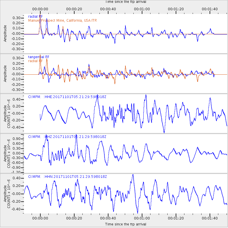
MPM Manuel Prospect Mine, California, USA - Earthquake Result Viewer
*The percent match for this event was below the threshold and hence no stack was calculated.
| Earthquake location: |
Loyalty Islands |
| Earthquake latitude/longitude: |
-21.8/168.9 |
| Earthquake time(UTC): |
2017/11/01 (305) 05:09:00 GMT |
| Earthquake Depth: |
10 km |
| Earthquake Magnitude: |
6.0 Mww |
| Earthquake Catalog/Contributor: |
NEIC PDE/us |
|
| Network: |
CI Caltech Regional Seismic Network |
| Station: |
MPM Manuel Prospect Mine, California, USA |
| Lat/Lon: |
36.06 N/117.49 W |
| Elevation: |
185 m |
|
| Distance: |
90.2 deg |
| Az: |
51.014 deg |
| Baz: |
243.068 deg |
| Ray Param: |
$rayparam |
*The percent match for this event was below the threshold and hence was not used in the summary stack. |
|
| Radial Match: |
76.350075 % |
| Radial Bump: |
400 |
| Transverse Match: |
78.229126 % |
| Transverse Bump: |
370 |
| SOD ConfigId: |
13570011 |
| Insert Time: |
2019-04-29 02:07:12.251 +0000 |
| GWidth: |
2.5 |
| Max Bumps: |
400 |
| Tol: |
0.001 |
|
Signal To Noise
| Channel | StoN | STA | LTA |
| CI:MPM: :HHZ:20171101T05:21:29.598018Z | 2.9886017 | 6.036126E-7 | 2.0197159E-7 |
| CI:MPM: :HHN:20171101T05:21:29.598018Z | 0.80458 | 9.25552E-8 | 1.1503542E-7 |
| CI:MPM: :HHE:20171101T05:21:29.598018Z | 2.1841252 | 2.991208E-7 | 1.3695224E-7 |
| Arrivals |
| Ps | |
| PpPs | |
| PsPs/PpSs | |


