You are here: Home > Network List > CI - Caltech Regional Seismic Network Stations List
> Station MPP McPhearson Peak > Earthquake Result Viewer
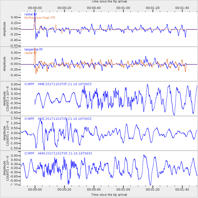
MPP McPhearson Peak - Earthquake Result Viewer
*The percent match for this event was below the threshold and hence no stack was calculated.
| Earthquake location: |
Loyalty Islands |
| Earthquake latitude/longitude: |
-21.8/168.9 |
| Earthquake time(UTC): |
2017/11/01 (305) 05:09:00 GMT |
| Earthquake Depth: |
10 km |
| Earthquake Magnitude: |
6.0 Mww |
| Earthquake Catalog/Contributor: |
NEIC PDE/us |
|
| Network: |
CI Caltech Regional Seismic Network |
| Station: |
MPP McPhearson Peak |
| Lat/Lon: |
34.89 N/119.81 W |
| Elevation: |
1739 m |
|
| Distance: |
88.0 deg |
| Az: |
51.169 deg |
| Baz: |
241.727 deg |
| Ray Param: |
$rayparam |
*The percent match for this event was below the threshold and hence was not used in the summary stack. |
|
| Radial Match: |
57.240845 % |
| Radial Bump: |
400 |
| Transverse Match: |
57.227047 % |
| Transverse Bump: |
400 |
| SOD ConfigId: |
13570011 |
| Insert Time: |
2019-04-29 02:07:12.908 +0000 |
| GWidth: |
2.5 |
| Max Bumps: |
400 |
| Tol: |
0.001 |
|
Signal To Noise
| Channel | StoN | STA | LTA |
| CI:MPP: :HHZ:20171101T05:21:19.197993Z | 4.9486856 | 9.3183706E-7 | 1.8829992E-7 |
| CI:MPP: :HHN:20171101T05:21:19.197993Z | 0.5436908 | 1.9692318E-7 | 3.62197E-7 |
| CI:MPP: :HHE:20171101T05:21:19.197993Z | 1.929941 | 4.43696E-7 | 2.2990132E-7 |
| Arrivals |
| Ps | |
| PpPs | |
| PsPs/PpSs | |


