You are here: Home > Network List > TA - USArray Transportable Network (new EarthScope stations) Stations List
> Station Q16A Castle Valley Ranch, Emery, UT, USA > Earthquake Result Viewer
Q16A Castle Valley Ranch, Emery, UT, USA - Earthquake Result Viewer

| Earthquake location: |
Near West Coast Of Colombia |
| Earthquake latitude/longitude: |
3.0/-78.0 |
| Earthquake time(UTC): |
2007/09/10 (253) 01:49:14 GMT |
| Earthquake Depth: |
31 km |
| Earthquake Magnitude: |
6.1 MB, 6.7 MS, 6.8 MW |
| Earthquake Catalog/Contributor: |
WHDF/NEIC |
|
| Network: |
TA USArray Transportable Network (new EarthScope stations) |
| Station: |
Q16A Castle Valley Ranch, Emery, UT, USA |
| Lat/Lon: |
38.92 N/111.17 W |
| Elevation: |
1912 m |
|
| Distance: |
46.8 deg |
| Az: |
324.142 deg |
| Baz: |
131.419 deg |
| Ray Param: |
0.07033503 |
| Estimated Moho Depth: |
56.5 km |
| Estimated Crust Vp/Vs: |
1.68 |
| Assumed Crust Vp: |
6.207 km/s |
| Estimated Crust Vs: |
3.7 km/s |
| Estimated Crust Poisson's Ratio: |
0.22 |
|
| Radial Match: |
97.38344 % |
| Radial Bump: |
288 |
| Transverse Match: |
87.071304 % |
| Transverse Bump: |
400 |
| SOD ConfigId: |
2564 |
| Insert Time: |
2010-03-06 05:49:30.201 +0000 |
| GWidth: |
2.5 |
| Max Bumps: |
400 |
| Tol: |
0.001 |
|
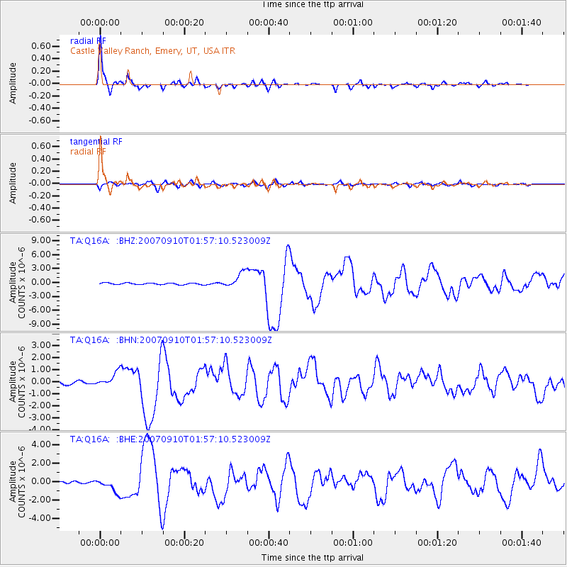
Signal To Noise
| Channel | StoN | STA | LTA |
| TA:Q16A: :BHN:20070910T01:57:10.523009Z | 4.6114607 | 5.9298145E-7 | 1.2858864E-7 |
| TA:Q16A: :BHE:20070910T01:57:10.523009Z | 8.248712 | 7.67642E-7 | 9.306205E-8 |
| TA:Q16A: :BHZ:20070910T01:57:10.523009Z | 10.065534 | 1.7282991E-6 | 1.7170467E-7 |
| Arrivals |
| Ps | 6.6 SECOND |
| PpPs | 23 SECOND |
| PsPs/PpSs | 29 SECOND |


