You are here: Home > Network List > CI - Caltech Regional Seismic Network Stations List
> Station SMM Simmler, CA, USA > Earthquake Result Viewer
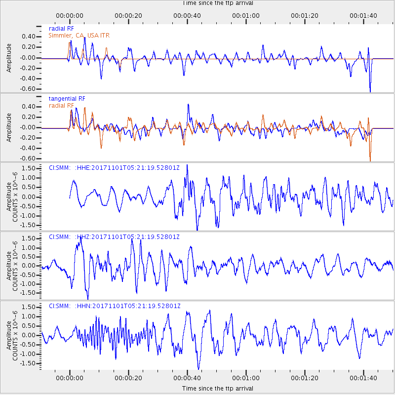
SMM Simmler, CA, USA - Earthquake Result Viewer
*The percent match for this event was below the threshold and hence no stack was calculated.
| Earthquake location: |
Loyalty Islands |
| Earthquake latitude/longitude: |
-21.8/168.9 |
| Earthquake time(UTC): |
2017/11/01 (305) 05:09:00 GMT |
| Earthquake Depth: |
10 km |
| Earthquake Magnitude: |
6.0 Mww |
| Earthquake Catalog/Contributor: |
NEIC PDE/us |
|
| Network: |
CI Caltech Regional Seismic Network |
| Station: |
SMM Simmler, CA, USA |
| Lat/Lon: |
35.31 N/120.00 W |
| Elevation: |
599 m |
|
| Distance: |
88.1 deg |
| Az: |
50.724 deg |
| Baz: |
241.608 deg |
| Ray Param: |
$rayparam |
*The percent match for this event was below the threshold and hence was not used in the summary stack. |
|
| Radial Match: |
63.14714 % |
| Radial Bump: |
400 |
| Transverse Match: |
50.692574 % |
| Transverse Bump: |
400 |
| SOD ConfigId: |
13570011 |
| Insert Time: |
2019-04-29 02:07:24.331 +0000 |
| GWidth: |
2.5 |
| Max Bumps: |
400 |
| Tol: |
0.001 |
|
Signal To Noise
| Channel | StoN | STA | LTA |
| CI:SMM: :HHZ:20171101T05:21:19.52801Z | 4.3655505 | 9.525098E-7 | 2.181878E-7 |
| CI:SMM: :HHN:20171101T05:21:19.52801Z | 1.0872458 | 2.6170144E-7 | 2.4070127E-7 |
| CI:SMM: :HHE:20171101T05:21:19.52801Z | 1.2285125 | 4.3493563E-7 | 3.5403434E-7 |
| Arrivals |
| Ps | |
| PpPs | |
| PsPs/PpSs | |


