You are here: Home > Network List > TA - USArray Transportable Network (new EarthScope stations) Stations List
> Station 109C Camp Elliot, Mirimar, CA, USA > Earthquake Result Viewer
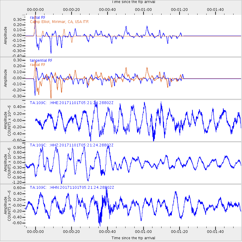
109C Camp Elliot, Mirimar, CA, USA - Earthquake Result Viewer
*The percent match for this event was below the threshold and hence no stack was calculated.
| Earthquake location: |
Loyalty Islands |
| Earthquake latitude/longitude: |
-21.8/168.9 |
| Earthquake time(UTC): |
2017/11/01 (305) 05:09:00 GMT |
| Earthquake Depth: |
10 km |
| Earthquake Magnitude: |
6.0 Mww |
| Earthquake Catalog/Contributor: |
NEIC PDE/us |
|
| Network: |
TA USArray Transportable Network (new EarthScope stations) |
| Station: |
109C Camp Elliot, Mirimar, CA, USA |
| Lat/Lon: |
32.89 N/117.11 W |
| Elevation: |
150 m |
|
| Distance: |
89.1 deg |
| Az: |
53.979 deg |
| Baz: |
243.303 deg |
| Ray Param: |
$rayparam |
*The percent match for this event was below the threshold and hence was not used in the summary stack. |
|
| Radial Match: |
72.85912 % |
| Radial Bump: |
298 |
| Transverse Match: |
70.96963 % |
| Transverse Bump: |
400 |
| SOD ConfigId: |
13570011 |
| Insert Time: |
2019-04-29 02:09:14.083 +0000 |
| GWidth: |
2.5 |
| Max Bumps: |
400 |
| Tol: |
0.001 |
|
Signal To Noise
| Channel | StoN | STA | LTA |
| TA:109C: :HHZ:20171101T05:21:24.28802Z | 2.6462886 | 5.6210325E-7 | 2.1241193E-7 |
| TA:109C: :HHN:20171101T05:21:24.28802Z | 1.4427919 | 2.5597166E-7 | 1.7741412E-7 |
| TA:109C: :HHE:20171101T05:21:24.28802Z | 2.2543206 | 3.427038E-7 | 1.5202087E-7 |
| Arrivals |
| Ps | |
| PpPs | |
| PsPs/PpSs | |


