You are here: Home > Network List > TA - USArray Transportable Network (new EarthScope stations) Stations List
> Station E20K Nigu River, AK, USA > Earthquake Result Viewer
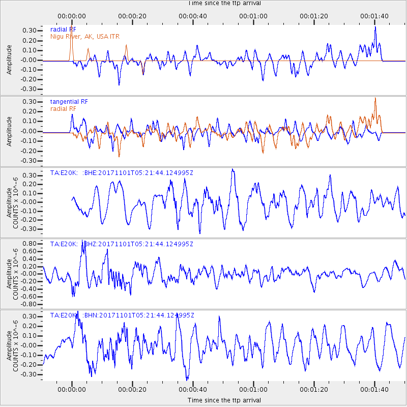
E20K Nigu River, AK, USA - Earthquake Result Viewer
*The percent match for this event was below the threshold and hence no stack was calculated.
| Earthquake location: |
Loyalty Islands |
| Earthquake latitude/longitude: |
-21.8/168.9 |
| Earthquake time(UTC): |
2017/11/01 (305) 05:09:00 GMT |
| Earthquake Depth: |
10 km |
| Earthquake Magnitude: |
6.0 Mww |
| Earthquake Catalog/Contributor: |
NEIC PDE/us |
|
| Network: |
TA USArray Transportable Network (new EarthScope stations) |
| Station: |
E20K Nigu River, AK, USA |
| Lat/Lon: |
68.26 N/156.19 W |
| Elevation: |
866 m |
|
| Distance: |
93.4 deg |
| Az: |
12.328 deg |
| Baz: |
212.179 deg |
| Ray Param: |
$rayparam |
*The percent match for this event was below the threshold and hence was not used in the summary stack. |
|
| Radial Match: |
62.19086 % |
| Radial Bump: |
400 |
| Transverse Match: |
61.562546 % |
| Transverse Bump: |
400 |
| SOD ConfigId: |
13570011 |
| Insert Time: |
2019-04-29 02:09:27.621 +0000 |
| GWidth: |
2.5 |
| Max Bumps: |
400 |
| Tol: |
0.001 |
|
Signal To Noise
| Channel | StoN | STA | LTA |
| TA:E20K: :BHZ:20171101T05:21:44.124995Z | 3.0467832 | 4.5280365E-7 | 1.4861696E-7 |
| TA:E20K: :BHN:20171101T05:21:44.124995Z | 1.5417422 | 1.9708031E-7 | 1.2782961E-7 |
| TA:E20K: :BHE:20171101T05:21:44.124995Z | 1.0051869 | 1.3370523E-7 | 1.3301529E-7 |
| Arrivals |
| Ps | |
| PpPs | |
| PsPs/PpSs | |


