You are here: Home > Network List > TA - USArray Transportable Network (new EarthScope stations) Stations List
> Station G16K Koyuk River, AK, USA > Earthquake Result Viewer
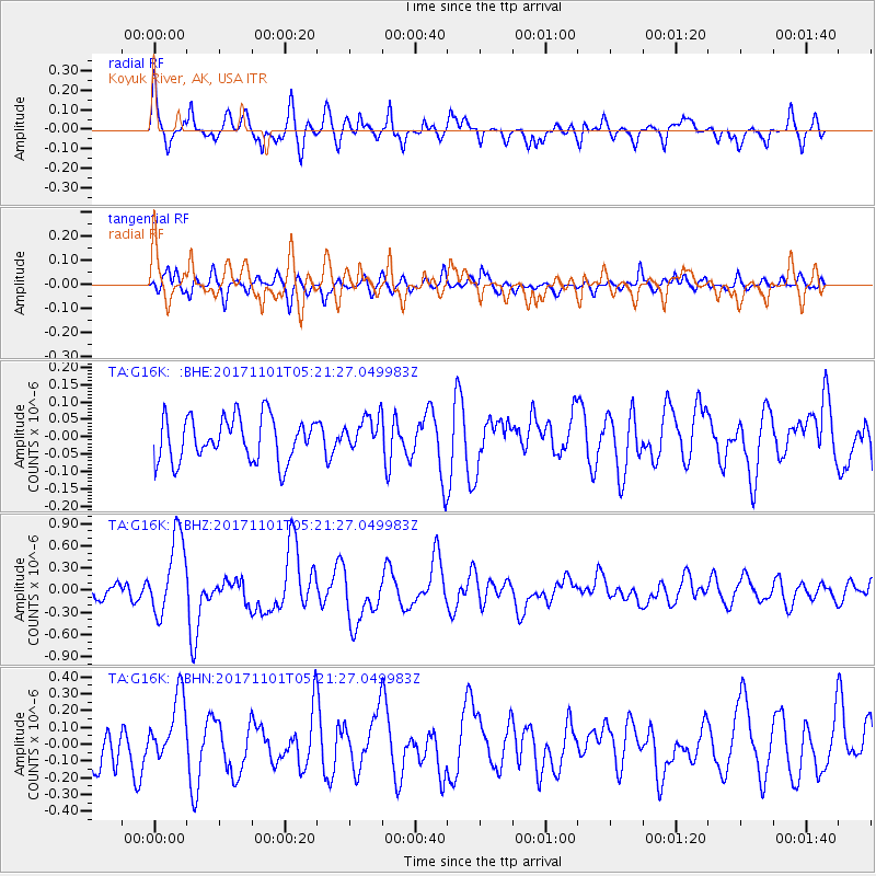
G16K Koyuk River, AK, USA - Earthquake Result Viewer
*The percent match for this event was below the threshold and hence no stack was calculated.
| Earthquake location: |
Loyalty Islands |
| Earthquake latitude/longitude: |
-21.8/168.9 |
| Earthquake time(UTC): |
2017/11/01 (305) 05:09:00 GMT |
| Earthquake Depth: |
10 km |
| Earthquake Magnitude: |
6.0 Mww |
| Earthquake Catalog/Contributor: |
NEIC PDE/us |
|
| Network: |
TA USArray Transportable Network (new EarthScope stations) |
| Station: |
G16K Koyuk River, AK, USA |
| Lat/Lon: |
65.39 N/162.35 W |
| Elevation: |
169 m |
|
| Distance: |
89.7 deg |
| Az: |
11.61 deg |
| Baz: |
206.532 deg |
| Ray Param: |
$rayparam |
*The percent match for this event was below the threshold and hence was not used in the summary stack. |
|
| Radial Match: |
74.90432 % |
| Radial Bump: |
400 |
| Transverse Match: |
56.33599 % |
| Transverse Bump: |
400 |
| SOD ConfigId: |
13570011 |
| Insert Time: |
2019-04-29 02:09:39.997 +0000 |
| GWidth: |
2.5 |
| Max Bumps: |
400 |
| Tol: |
0.001 |
|
Signal To Noise
| Channel | StoN | STA | LTA |
| TA:G16K: :BHZ:20171101T05:21:27.049983Z | 3.6942105 | 5.370677E-7 | 1.4538092E-7 |
| TA:G16K: :BHN:20171101T05:21:27.049983Z | 1.8038421 | 1.9231292E-7 | 1.0661295E-7 |
| TA:G16K: :BHE:20171101T05:21:27.049983Z | 0.7805405 | 4.897621E-8 | 6.274654E-8 |
| Arrivals |
| Ps | |
| PpPs | |
| PsPs/PpSs | |


