You are here: Home > Network List > TA - USArray Transportable Network (new EarthScope stations) Stations List
> Station M11K Mekoryuk, AK, USA > Earthquake Result Viewer
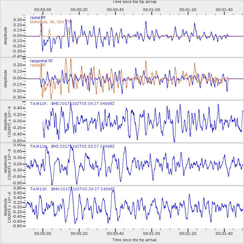
M11K Mekoryuk, AK, USA - Earthquake Result Viewer
*The percent match for this event was below the threshold and hence no stack was calculated.
| Earthquake location: |
Loyalty Islands |
| Earthquake latitude/longitude: |
-21.8/168.8 |
| Earthquake time(UTC): |
2017/11/02 (306) 03:27:27 GMT |
| Earthquake Depth: |
10 km |
| Earthquake Magnitude: |
5.6 Mww |
| Earthquake Catalog/Contributor: |
NEIC PDE/us |
|
| Network: |
TA USArray Transportable Network (new EarthScope stations) |
| Station: |
M11K Mekoryuk, AK, USA |
| Lat/Lon: |
60.38 N/166.20 W |
| Elevation: |
3.0 m |
|
| Distance: |
84.4 deg |
| Az: |
12.181 deg |
| Baz: |
203.25 deg |
| Ray Param: |
$rayparam |
*The percent match for this event was below the threshold and hence was not used in the summary stack. |
|
| Radial Match: |
56.336212 % |
| Radial Bump: |
400 |
| Transverse Match: |
59.616135 % |
| Transverse Bump: |
400 |
| SOD ConfigId: |
13570011 |
| Insert Time: |
2019-04-29 02:16:06.369 +0000 |
| GWidth: |
2.5 |
| Max Bumps: |
400 |
| Tol: |
0.001 |
|
Signal To Noise
| Channel | StoN | STA | LTA |
| TA:M11K: :BHZ:20171102T03:39:27.34998Z | 2.1401935 | 4.6897898E-7 | 2.1912925E-7 |
| TA:M11K: :BHN:20171102T03:39:27.34998Z | 0.6152379 | 1.7404817E-7 | 2.828957E-7 |
| TA:M11K: :BHE:20171102T03:39:27.34998Z | 0.8248163 | 1.8698026E-7 | 2.2669322E-7 |
| Arrivals |
| Ps | |
| PpPs | |
| PsPs/PpSs | |


