You are here: Home > Network List > TA - USArray Transportable Network (new EarthScope stations) Stations List
> Station N15K Kwethluk River, AK, USA > Earthquake Result Viewer
N15K Kwethluk River, AK, USA - Earthquake Result Viewer
| Earthquake location: |
Loyalty Islands |
| Earthquake latitude/longitude: |
-21.8/168.8 |
| Earthquake time(UTC): |
2017/11/02 (306) 03:27:27 GMT |
| Earthquake Depth: |
10 km |
| Earthquake Magnitude: |
5.6 Mww |
| Earthquake Catalog/Contributor: |
NEIC PDE/us |
|
| Network: |
TA USArray Transportable Network (new EarthScope stations) |
| Station: |
N15K Kwethluk River, AK, USA |
| Lat/Lon: |
60.17 N/160.09 W |
| Elevation: |
449 m |
|
| Distance: |
85.5 deg |
| Az: |
15.021 deg |
| Baz: |
208.796 deg |
| Ray Param: |
0.04468834 |
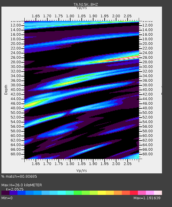
| Estimated Moho Depth: |
26.0 km |
| Estimated Crust Vp/Vs: |
2.05 |
| Assumed Crust Vp: |
6.182 km/s |
| Estimated Crust Vs: |
3.012 km/s |
| Estimated Crust Poisson's Ratio: |
0.34 |
|
| Radial Match: |
80.80685 % |
| Radial Bump: |
323 |
| Transverse Match: |
53.44574 % |
| Transverse Bump: |
377 |
| SOD ConfigId: |
13570011 |
| Insert Time: |
2019-04-29 02:16:12.317 +0000 |
| GWidth: |
2.5 |
| Max Bumps: |
400 |
| Tol: |
0.001 |
|

Signal To Noise
| Channel | StoN | STA | LTA |
| TA:N15K: :BHZ:20171102T03:39:33.049993Z | 3.2050433 | 4.1099042E-7 | 1.2823241E-7 |
| TA:N15K: :BHN:20171102T03:39:33.049993Z | 2.7015564 | 3.395311E-7 | 1.2567982E-7 |
| TA:N15K: :BHE:20171102T03:39:33.049993Z | 2.116629 | 2.4252222E-7 | 1.1457948E-7 |
| Arrivals |
| Ps | 4.5 SECOND |
| PpPs | 13 SECOND |
| PsPs/PpSs | 17 SECOND |


