You are here: Home > Network List > TA - USArray Transportable Network (new EarthScope stations) Stations List
> Station R17K Ugashik Creek, AK, USA > Earthquake Result Viewer
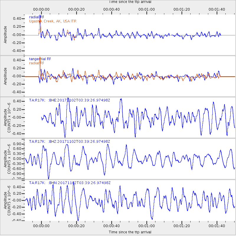
R17K Ugashik Creek, AK, USA - Earthquake Result Viewer
*The percent match for this event was below the threshold and hence no stack was calculated.
| Earthquake location: |
Loyalty Islands |
| Earthquake latitude/longitude: |
-21.8/168.8 |
| Earthquake time(UTC): |
2017/11/02 (306) 03:27:27 GMT |
| Earthquake Depth: |
10 km |
| Earthquake Magnitude: |
5.6 Mww |
| Earthquake Catalog/Contributor: |
NEIC PDE/us |
|
| Network: |
TA USArray Transportable Network (new EarthScope stations) |
| Station: |
R17K Ugashik Creek, AK, USA |
| Lat/Lon: |
57.64 N/156.39 W |
| Elevation: |
273 m |
|
| Distance: |
84.3 deg |
| Az: |
17.977 deg |
| Baz: |
212.225 deg |
| Ray Param: |
$rayparam |
*The percent match for this event was below the threshold and hence was not used in the summary stack. |
|
| Radial Match: |
73.22305 % |
| Radial Bump: |
400 |
| Transverse Match: |
57.152588 % |
| Transverse Bump: |
400 |
| SOD ConfigId: |
13570011 |
| Insert Time: |
2019-04-29 02:16:26.587 +0000 |
| GWidth: |
2.5 |
| Max Bumps: |
400 |
| Tol: |
0.001 |
|
Signal To Noise
| Channel | StoN | STA | LTA |
| TA:R17K: :BHZ:20171102T03:39:26.97498Z | 2.7323394 | 6.5136777E-7 | 2.3839195E-7 |
| TA:R17K: :BHN:20171102T03:39:26.97498Z | 1.4933549 | 1.8311694E-7 | 1.2262117E-7 |
| TA:R17K: :BHE:20171102T03:39:26.97498Z | 0.7907519 | 1.5721592E-7 | 1.9881827E-7 |
| Arrivals |
| Ps | |
| PpPs | |
| PsPs/PpSs | |


