You are here: Home > Network List > TA - USArray Transportable Network (new EarthScope stations) Stations List
> Station Q16A Castle Valley Ranch, Emery, UT, USA > Earthquake Result Viewer
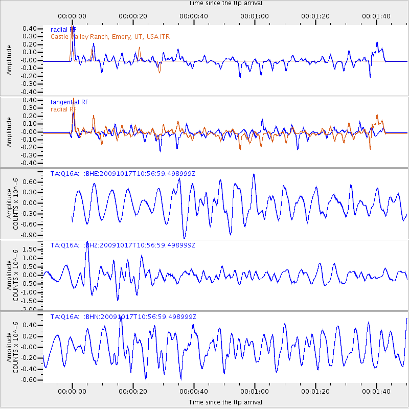
Q16A Castle Valley Ranch, Emery, UT, USA - Earthquake Result Viewer
*The percent match for this event was below the threshold and hence no stack was calculated.
| Earthquake location: |
Samoa Islands Region |
| Earthquake latitude/longitude: |
-16.4/-172.0 |
| Earthquake time(UTC): |
2009/10/17 (290) 10:45:26 GMT |
| Earthquake Depth: |
10 km |
| Earthquake Magnitude: |
5.7 MB, 5.3 MS, 5.7 MW, 5.7 MW |
| Earthquake Catalog/Contributor: |
WHDF/NEIC |
|
| Network: |
TA USArray Transportable Network (new EarthScope stations) |
| Station: |
Q16A Castle Valley Ranch, Emery, UT, USA |
| Lat/Lon: |
38.92 N/111.17 W |
| Elevation: |
1912 m |
|
| Distance: |
79.0 deg |
| Az: |
43.925 deg |
| Baz: |
238.614 deg |
| Ray Param: |
$rayparam |
*The percent match for this event was below the threshold and hence was not used in the summary stack. |
|
| Radial Match: |
60.76295 % |
| Radial Bump: |
341 |
| Transverse Match: |
55.244247 % |
| Transverse Bump: |
289 |
| SOD ConfigId: |
2622 |
| Insert Time: |
2010-03-06 05:51:27.023 +0000 |
| GWidth: |
2.5 |
| Max Bumps: |
400 |
| Tol: |
0.001 |
|
Signal To Noise
| Channel | StoN | STA | LTA |
| TA:Q16A: :BHZ:20091017T10:56:59.498999Z | 4.73207 | 6.347394E-7 | 1.3413569E-7 |
| TA:Q16A: :BHN:20091017T10:56:59.498999Z | 0.7064427 | 1.269646E-7 | 1.7972384E-7 |
| TA:Q16A: :BHE:20091017T10:56:59.498999Z | 1.2082464 | 3.6941415E-7 | 3.0574407E-7 |
| Arrivals |
| Ps | |
| PpPs | |
| PsPs/PpSs | |


