You are here: Home > Network List > TA - USArray Transportable Network (new EarthScope stations) Stations List
> Station Q16A Castle Valley Ranch, Emery, UT, USA > Earthquake Result Viewer
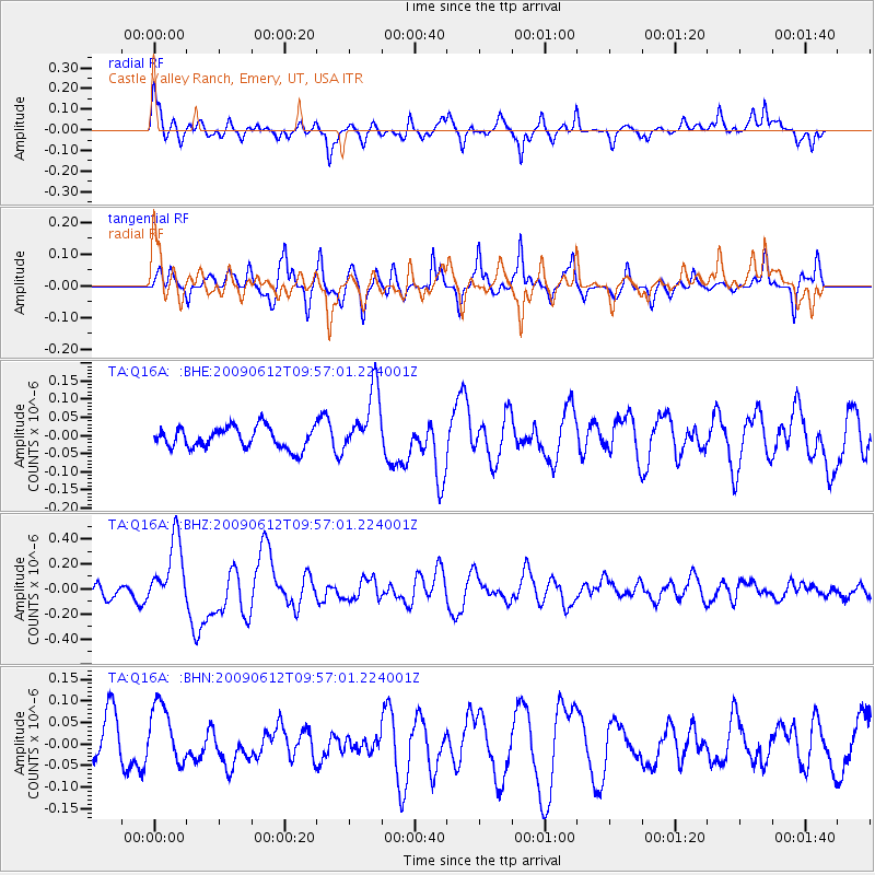
Q16A Castle Valley Ranch, Emery, UT, USA - Earthquake Result Viewer
*The percent match for this event was below the threshold and hence no stack was calculated.
| Earthquake location: |
Vanuatu Islands |
| Earthquake latitude/longitude: |
-17.6/167.8 |
| Earthquake time(UTC): |
2009/06/12 (163) 09:44:15 GMT |
| Earthquake Depth: |
15 km |
| Earthquake Magnitude: |
5.5 MB, 5.6 MS, 6.0 MW, 6.0 MW |
| Earthquake Catalog/Contributor: |
WHDF/NEIC |
|
| Network: |
TA USArray Transportable Network (new EarthScope stations) |
| Station: |
Q16A Castle Valley Ranch, Emery, UT, USA |
| Lat/Lon: |
38.92 N/111.17 W |
| Elevation: |
1912 m |
|
| Distance: |
94.1 deg |
| Az: |
50.583 deg |
| Baz: |
250.815 deg |
| Ray Param: |
$rayparam |
*The percent match for this event was below the threshold and hence was not used in the summary stack. |
|
| Radial Match: |
74.80491 % |
| Radial Bump: |
400 |
| Transverse Match: |
64.544685 % |
| Transverse Bump: |
400 |
| SOD ConfigId: |
2648 |
| Insert Time: |
2010-03-06 05:51:48.376 +0000 |
| GWidth: |
2.5 |
| Max Bumps: |
400 |
| Tol: |
0.001 |
|
Signal To Noise
| Channel | StoN | STA | LTA |
| TA:Q16A: :BHZ:20090612T09:57:01.224001Z | 3.4145913 | 2.6750143E-7 | 7.834068E-8 |
| TA:Q16A: :BHN:20090612T09:57:01.224001Z | 1.2843027 | 7.072542E-8 | 5.506912E-8 |
| TA:Q16A: :BHE:20090612T09:57:01.224001Z | 3.0936959 | 8.960239E-8 | 2.8962893E-8 |
| Arrivals |
| Ps | |
| PpPs | |
| PsPs/PpSs | |


