You are here: Home > Network List > GS - US Geological Survey Networks Stations List
> Station OK031 2598 S. Brethren Rd., Cushing, OK, USA > Earthquake Result Viewer
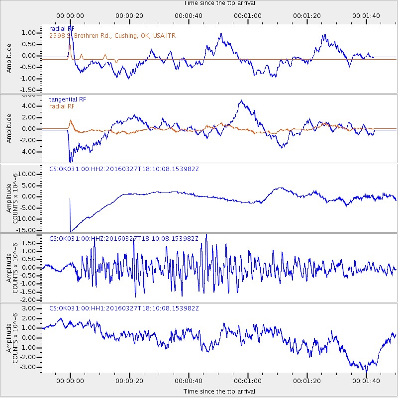
OK031 2598 S. Brethren Rd., Cushing, OK, USA - Earthquake Result Viewer
*The percent match for this event was below the threshold and hence no stack was calculated.
| Earthquake location: |
Fox Islands, Aleutian Islands |
| Earthquake latitude/longitude: |
52.2/-168.7 |
| Earthquake time(UTC): |
2016/03/27 (087) 18:01:30 GMT |
| Earthquake Depth: |
16 km |
| Earthquake Magnitude: |
5.7 MWB |
| Earthquake Catalog/Contributor: |
NEIC PDE/NEIC COMCAT |
|
| Network: |
GS US Geological Survey Networks |
| Station: |
OK031 2598 S. Brethren Rd., Cushing, OK, USA |
| Lat/Lon: |
35.95 N/96.84 W |
| Elevation: |
290 m |
|
| Distance: |
52.0 deg |
| Az: |
78.19 deg |
| Baz: |
312.036 deg |
| Ray Param: |
$rayparam |
*The percent match for this event was below the threshold and hence was not used in the summary stack. |
|
| Radial Match: |
40.93973 % |
| Radial Bump: |
400 |
| Transverse Match: |
51.61791 % |
| Transverse Bump: |
400 |
| SOD ConfigId: |
1475611 |
| Insert Time: |
2016-04-11 16:19:49.476 +0000 |
| GWidth: |
2.5 |
| Max Bumps: |
400 |
| Tol: |
0.001 |
|
Signal To Noise
| Channel | StoN | STA | LTA |
| GS:OK031:00:HHZ:20160327T18:10:08.153982Z | 2.5286064 | 3.8347795E-7 | 1.5165585E-7 |
| GS:OK031:00:HH1:20160327T18:10:08.153982Z | 1.1571784 | 6.291448E-6 | 5.4368866E-6 |
| GS:OK031:00:HH2:20160327T18:10:08.153982Z | 1.2447307 | 6.74594E-6 | 5.419598E-6 |
| Arrivals |
| Ps | |
| PpPs | |
| PsPs/PpSs | |


