You are here: Home > Network List > TA - USArray Transportable Network (new EarthScope stations) Stations List
> Station I23K Minto, Yukon-Koyukuk, AK, USA > Earthquake Result Viewer
I23K Minto, Yukon-Koyukuk, AK, USA - Earthquake Result Viewer
*The percent match for this event was below the threshold and hence no stack was calculated.
| Earthquake location: |
Off Coast Of Jalisco, Mexico |
| Earthquake latitude/longitude: |
18.7/-106.6 |
| Earthquake time(UTC): |
2017/11/03 (307) 11:52:10 GMT |
| Earthquake Depth: |
10 km |
| Earthquake Magnitude: |
5.7 Mww |
| Earthquake Catalog/Contributor: |
NEIC PDE/us |
|
| Network: |
TA USArray Transportable Network (new EarthScope stations) |
| Station: |
I23K Minto, Yukon-Koyukuk, AK, USA |
| Lat/Lon: |
65.15 N/149.36 W |
| Elevation: |
149 m |
|
| Distance: |
54.3 deg |
| Az: |
339.326 deg |
| Baz: |
127.657 deg |
| Ray Param: |
$rayparam |
*The percent match for this event was below the threshold and hence was not used in the summary stack. |
|
| Radial Match: |
64.53602 % |
| Radial Bump: |
348 |
| Transverse Match: |
50.06705 % |
| Transverse Bump: |
400 |
| SOD ConfigId: |
13570011 |
| Insert Time: |
2019-04-29 02:27:34.910 +0000 |
| GWidth: |
2.5 |
| Max Bumps: |
400 |
| Tol: |
0.001 |
|
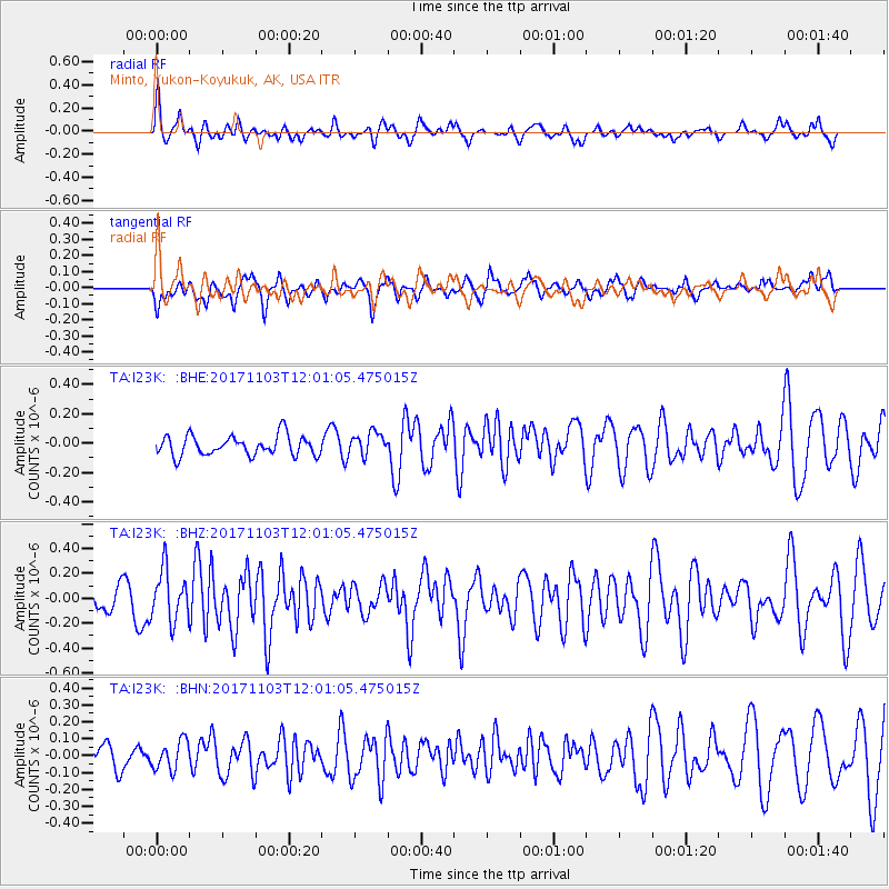
Signal To Noise
| Channel | StoN | STA | LTA |
| TA:I23K: :BHZ:20171103T12:01:05.475015Z | 2.5567439 | 2.0208624E-7 | 7.904047E-8 |
| TA:I23K: :BHN:20171103T12:01:05.475015Z | 1.0423329 | 8.565125E-8 | 8.217265E-8 |
| TA:I23K: :BHE:20171103T12:01:05.475015Z | 1.150382 | 7.748683E-8 | 6.7357476E-8 |
| Arrivals |
| Ps | |
| PpPs | |
| PsPs/PpSs | |


