You are here: Home > Network List > TA - USArray Transportable Network (new EarthScope stations) Stations List
> Station P14A Drum Mountains (BLM), Topaz, UT, USA > Earthquake Result Viewer
P14A Drum Mountains (BLM), Topaz, UT, USA - Earthquake Result Viewer
| Earthquake location: |
Central Mid-Atlantic Ridge |
| Earthquake latitude/longitude: |
8.1/-38.7 |
| Earthquake time(UTC): |
2008/09/10 (254) 13:08:14 GMT |
| Earthquake Depth: |
10 km |
| Earthquake Magnitude: |
6.3 MB, 6.5 MS, 6.6 MW, 6.6 MW |
| Earthquake Catalog/Contributor: |
WHDF/NEIC |
|
| Network: |
TA USArray Transportable Network (new EarthScope stations) |
| Station: |
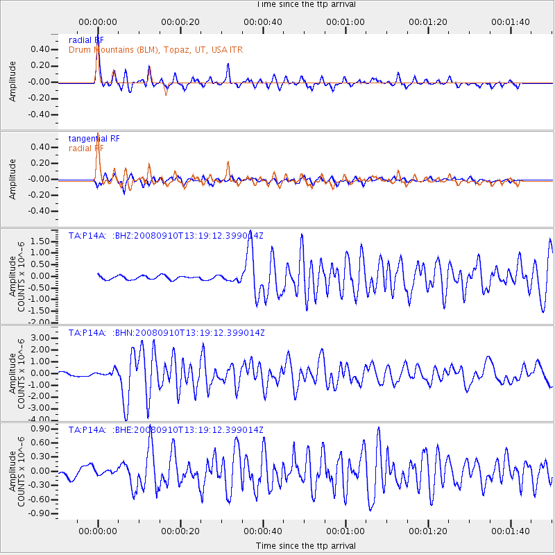
P14A Drum Mountains (BLM), Topaz, UT, USA |
| Lat/Lon: |
39.59 N/113.07 W |
| Elevation: |
1784 m |
|
| Distance: |
72.8 deg |
| Az: |
308.852 deg |
| Baz: |
93.69 deg |
| Ray Param: |
0.053400993 |
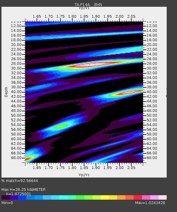
| Estimated Moho Depth: |
28.25 km |
| Estimated Crust Vp/Vs: |
1.87 |
| Assumed Crust Vp: |
6.276 km/s |
| Estimated Crust Vs: |
3.352 km/s |
| Estimated Crust Poisson's Ratio: |
0.30 |
|
| Radial Match: |
92.56644 % |
| Radial Bump: |
347 |
| Transverse Match: |
85.42179 % |
| Transverse Bump: |
400 |
| SOD ConfigId: |
2560 |
| Insert Time: |
2010-03-06 05:53:20.117 +0000 |
| GWidth: |
2.5 |
| Max Bumps: |
400 |
| Tol: |
0.001 |
|
Signal To Noise
| Channel | StoN | STA | LTA |
| TA:P14A: :BHN:20080910T13:19:12.399014Z | 1.88335 | 2.421688E-7 | 1.2858406E-7 |
| TA:P14A: :BHE:20080910T13:19:12.399014Z | 0.63901865 | 6.076489E-8 | 9.5090954E-8 |
| TA:P14A: :BHZ:20080910T13:19:12.399014Z | 1.463987 | 1.2078706E-7 | 8.2505565E-8 |
| Arrivals |
| Ps | 4.1 SECOND |
| PpPs | 13 SECOND |
| PsPs/PpSs | 17 SECOND |


