You are here: Home > Network List > AK - Alaska Regional Network Stations List
> Station RKAV Rock Avalanche, AK, USA > Earthquake Result Viewer
RKAV Rock Avalanche, AK, USA - Earthquake Result Viewer
| Earthquake location: |
Tonga Islands |
| Earthquake latitude/longitude: |
-15.4/-173.2 |
| Earthquake time(UTC): |
2017/11/04 (308) 09:00:19 GMT |
| Earthquake Depth: |
10 km |
| Earthquake Magnitude: |
6.8 Mww |
| Earthquake Catalog/Contributor: |
NEIC PDE/us |
|
| Network: |
AK Alaska Regional Network |
| Station: |
RKAV Rock Avalanche, AK, USA |
| Lat/Lon: |
60.30 N/141.35 W |
| Elevation: |
1647 m |
|
| Distance: |
79.6 deg |
| Az: |
15.503 deg |
| Baz: |
211.187 deg |
| Ray Param: |
0.04881971 |
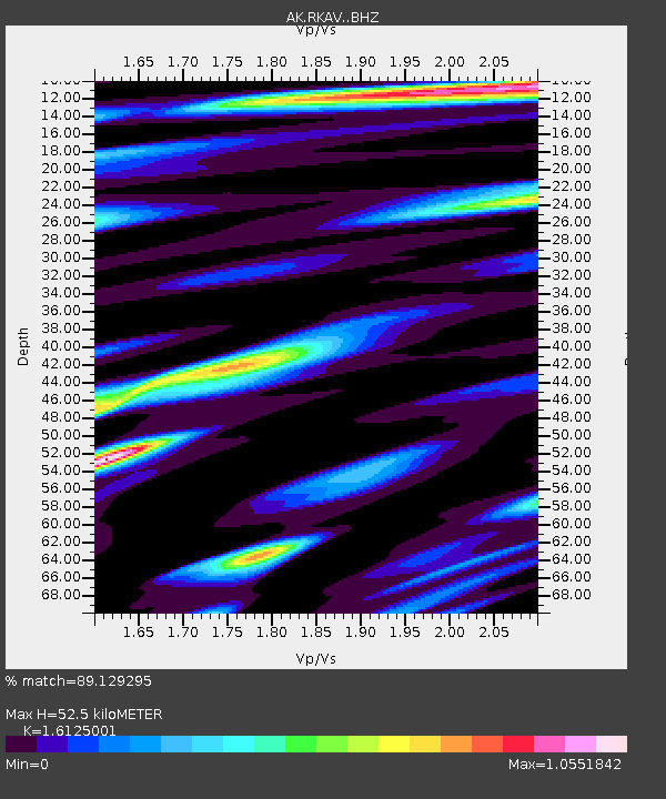
| Estimated Moho Depth: |
52.5 km |
| Estimated Crust Vp/Vs: |
1.61 |
| Assumed Crust Vp: |
6.566 km/s |
| Estimated Crust Vs: |
4.072 km/s |
| Estimated Crust Poisson's Ratio: |
0.19 |
|
| Radial Match: |
89.129295 % |
| Radial Bump: |
400 |
| Transverse Match: |
86.687096 % |
| Transverse Bump: |
400 |
| SOD ConfigId: |
13570011 |
| Insert Time: |
2019-04-29 02:30:06.264 +0000 |
| GWidth: |
2.5 |
| Max Bumps: |
400 |
| Tol: |
0.001 |
|

Signal To Noise
| Channel | StoN | STA | LTA |
| AK:RKAV: :BHZ:20171104T09:11:55.248005Z | 38.296314 | 4.1522117E-6 | 1.0842327E-7 |
| AK:RKAV: :BHN:20171104T09:11:55.248005Z | 8.308001 | 1.3732761E-6 | 1.6529562E-7 |
| AK:RKAV: :BHE:20171104T09:11:55.248005Z | 10.112581 | 1.2487849E-6 | 1.2348825E-7 |
| Arrivals |
| Ps | 5.1 SECOND |
| PpPs | 20 SECOND |
| PsPs/PpSs | 25 SECOND |


