You are here: Home > Network List > TA - USArray Transportable Network (new EarthScope stations) Stations List
> Station P14A Drum Mountains (BLM), Topaz, UT, USA > Earthquake Result Viewer
P14A Drum Mountains (BLM), Topaz, UT, USA - Earthquake Result Viewer
| Earthquake location: |
Near West Coast Of Colombia |
| Earthquake latitude/longitude: |
3.0/-78.0 |
| Earthquake time(UTC): |
2007/09/10 (253) 01:49:14 GMT |
| Earthquake Depth: |
31 km |
| Earthquake Magnitude: |
6.1 MB, 6.7 MS, 6.8 MW |
| Earthquake Catalog/Contributor: |
WHDF/NEIC |
|
| Network: |
TA USArray Transportable Network (new EarthScope stations) |
| Station: |
P14A Drum Mountains (BLM), Topaz, UT, USA |
| Lat/Lon: |
39.59 N/113.07 W |
| Elevation: |
1784 m |
|
| Distance: |
48.4 deg |
| Az: |
323.534 deg |
| Baz: |
129.814 deg |
| Ray Param: |
0.06933838 |
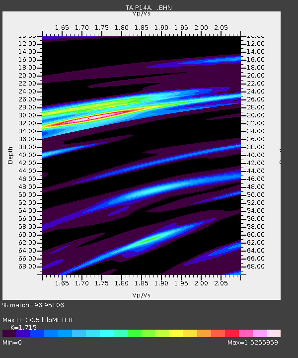
| Estimated Moho Depth: |
30.5 km |
| Estimated Crust Vp/Vs: |
1.72 |
| Assumed Crust Vp: |
6.276 km/s |
| Estimated Crust Vs: |
3.659 km/s |
| Estimated Crust Poisson's Ratio: |
0.24 |
|
| Radial Match: |
96.95106 % |
| Radial Bump: |
400 |
| Transverse Match: |
85.32315 % |
| Transverse Bump: |
400 |
| SOD ConfigId: |
2564 |
| Insert Time: |
2010-03-06 05:53:58.605 +0000 |
| GWidth: |
2.5 |
| Max Bumps: |
400 |
| Tol: |
0.001 |
|
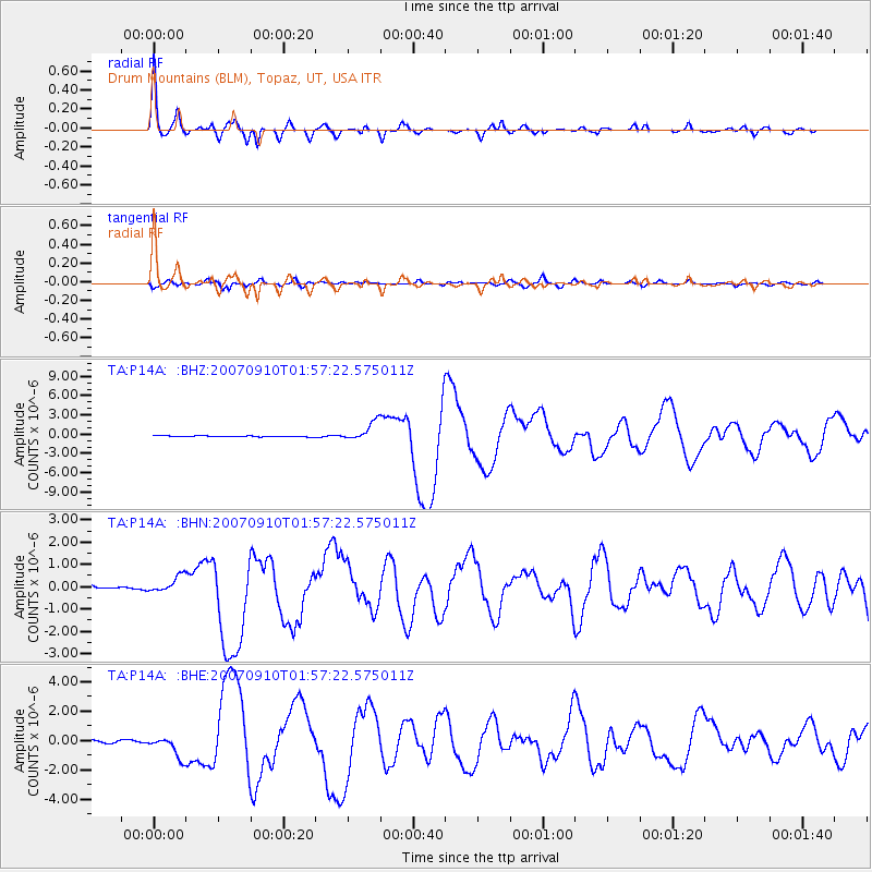
Signal To Noise
| Channel | StoN | STA | LTA |
| TA:P14A: :BHN:20070910T01:57:22.575011Z | 5.042342 | 3.6211645E-7 | 7.181514E-8 |
| TA:P14A: :BHE:20070910T01:57:22.575011Z | 7.312226 | 7.121473E-7 | 9.7391315E-8 |
| TA:P14A: :BHZ:20070910T01:57:22.575011Z | 18.108269 | 1.4709648E-6 | 8.123166E-8 |
| Arrivals |
| Ps | 3.7 SECOND |
| PpPs | 12 SECOND |
| PsPs/PpSs | 16 SECOND |


