You are here: Home > Network List > AV - Alaska Volcano Observatory Stations List
> Station AKSA Akutan Strait, Akutan Volcano, Alaska > Earthquake Result Viewer
AKSA Akutan Strait, Akutan Volcano, Alaska - Earthquake Result Viewer

| Earthquake location: |
Tonga Islands |
| Earthquake latitude/longitude: |
-15.4/-173.2 |
| Earthquake time(UTC): |
2017/11/04 (308) 09:00:19 GMT |
| Earthquake Depth: |
10 km |
| Earthquake Magnitude: |
6.8 Mww |
| Earthquake Catalog/Contributor: |
NEIC PDE/us |
|
| Network: |
AV Alaska Volcano Observatory |
| Station: |
AKSA Akutan Strait, Akutan Volcano, Alaska |
| Lat/Lon: |
54.11 N/165.70 W |
| Elevation: |
213 m |
|
| Distance: |
69.5 deg |
| Az: |
4.72 deg |
| Baz: |
187.748 deg |
| Ray Param: |
0.055616572 |
| Estimated Moho Depth: |
51.75 km |
| Estimated Crust Vp/Vs: |
1.88 |
| Assumed Crust Vp: |
5.989 km/s |
| Estimated Crust Vs: |
3.194 km/s |
| Estimated Crust Poisson's Ratio: |
0.30 |
|
| Radial Match: |
88.25034 % |
| Radial Bump: |
395 |
| Transverse Match: |
70.60002 % |
| Transverse Bump: |
400 |
| SOD ConfigId: |
13570011 |
| Insert Time: |
2019-04-29 02:30:59.492 +0000 |
| GWidth: |
2.5 |
| Max Bumps: |
400 |
| Tol: |
0.001 |
|
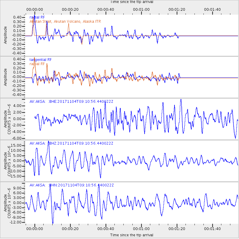
Signal To Noise
| Channel | StoN | STA | LTA |
| AV:AKSA: :BHZ:20171104T09:10:56.440022Z | 6.805813 | 7.916946E-6 | 1.1632624E-6 |
| AV:AKSA: :BHN:20171104T09:10:56.440022Z | 2.8943846 | 3.2752962E-6 | 1.1316037E-6 |
| AV:AKSA: :BHE:20171104T09:10:56.440022Z | 2.099727 | 2.1849E-6 | 1.0405638E-6 |
| Arrivals |
| Ps | 7.8 SECOND |
| PpPs | 24 SECOND |
| PsPs/PpSs | 32 SECOND |


