You are here: Home > Network List > AV - Alaska Volcano Observatory Stations List
> Station AUL Lava Flow, Augustine Volcano, Alaska > Earthquake Result Viewer
AUL Lava Flow, Augustine Volcano, Alaska - Earthquake Result Viewer
| Earthquake location: |
Tonga Islands |
| Earthquake latitude/longitude: |
-15.4/-173.2 |
| Earthquake time(UTC): |
2017/11/04 (308) 09:00:19 GMT |
| Earthquake Depth: |
10 km |
| Earthquake Magnitude: |
6.8 Mww |
| Earthquake Catalog/Contributor: |
NEIC PDE/us |
|
| Network: |
AV Alaska Volcano Observatory |
| Station: |
AUL Lava Flow, Augustine Volcano, Alaska |
| Lat/Lon: |
59.38 N/153.44 W |
| Elevation: |
360 m |
|
| Distance: |
76.2 deg |
| Az: |
10.275 deg |
| Baz: |
199.646 deg |
| Ray Param: |
0.05115588 |
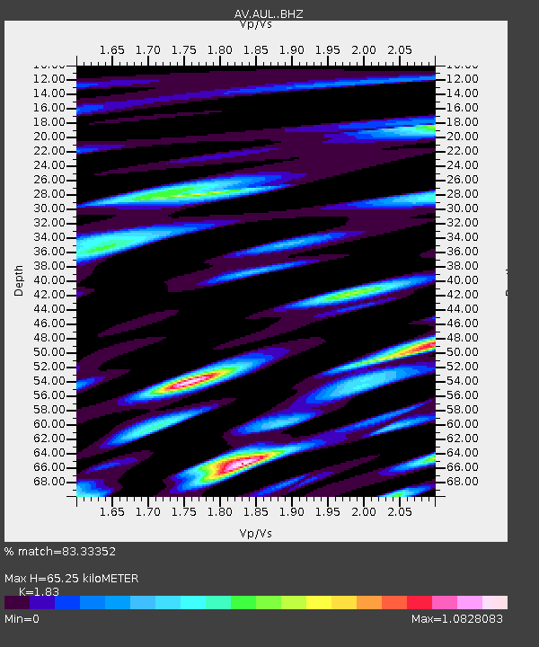
| Estimated Moho Depth: |
65.25 km |
| Estimated Crust Vp/Vs: |
1.83 |
| Assumed Crust Vp: |
5.989 km/s |
| Estimated Crust Vs: |
3.273 km/s |
| Estimated Crust Poisson's Ratio: |
0.29 |
|
| Radial Match: |
83.33352 % |
| Radial Bump: |
400 |
| Transverse Match: |
82.83927 % |
| Transverse Bump: |
400 |
| SOD ConfigId: |
13570011 |
| Insert Time: |
2019-04-29 02:31:03.592 +0000 |
| GWidth: |
2.5 |
| Max Bumps: |
400 |
| Tol: |
0.001 |
|

Signal To Noise
| Channel | StoN | STA | LTA |
| AV:AUL: :BHZ:20171104T09:11:36.159016Z | 15.084949 | 6.1485734E-6 | 4.075966E-7 |
| AV:AUL: :BHN:20171104T09:11:36.159016Z | 5.182823 | 2.756376E-6 | 5.318291E-7 |
| AV:AUL: :BHE:20171104T09:11:36.159016Z | 1.7112494 | 1.3086502E-6 | 7.6473384E-7 |
| Arrivals |
| Ps | 9.3 SECOND |
| PpPs | 30 SECOND |
| PsPs/PpSs | 39 SECOND |


