You are here: Home > Network List > AV - Alaska Volcano Observatory Stations List
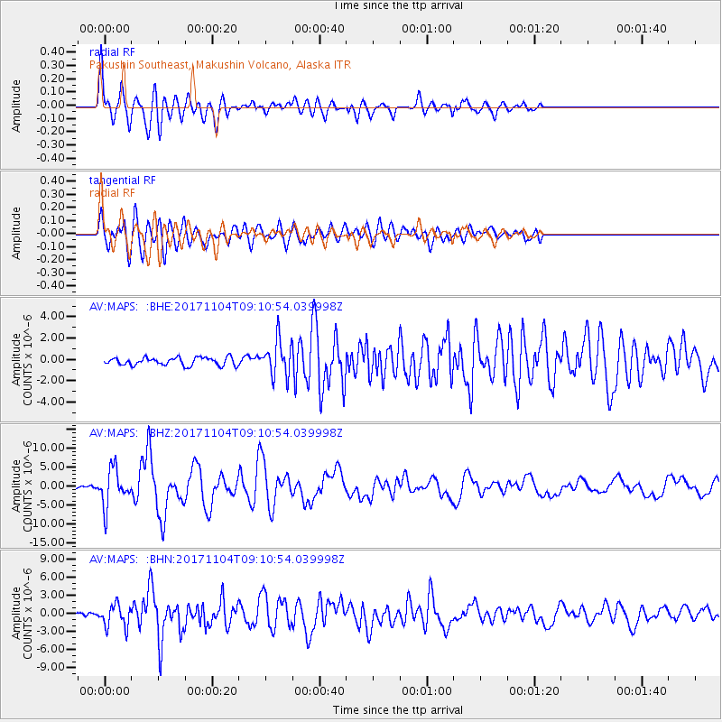
> Station MAPS Pakushin Southeast, Makushin Volcano, Alaska > Earthquake Result Viewer
MAPS Pakushin Southeast, Makushin Volcano, Alaska - Earthquake Result Viewer
| Earthquake location: |
Tonga Islands |
| Earthquake latitude/longitude: |
-15.4/-173.2 |
| Earthquake time(UTC): |
2017/11/04 (308) 09:00:19 GMT |
| Earthquake Depth: |
10 km |
| Earthquake Magnitude: |
6.8 Mww |
| Earthquake Catalog/Contributor: |
NEIC PDE/us |
|
| Network: |
AV Alaska Volcano Observatory |
| Station: |
MAPS Pakushin Southeast, Makushin Volcano, Alaska |
| Lat/Lon: |
53.81 N/166.94 W |
| Elevation: |
333 m |
|
| Distance: |
69.1 deg |
| Az: |
3.981 deg |
| Baz: |
186.485 deg |
| Ray Param: |
0.055874545 |
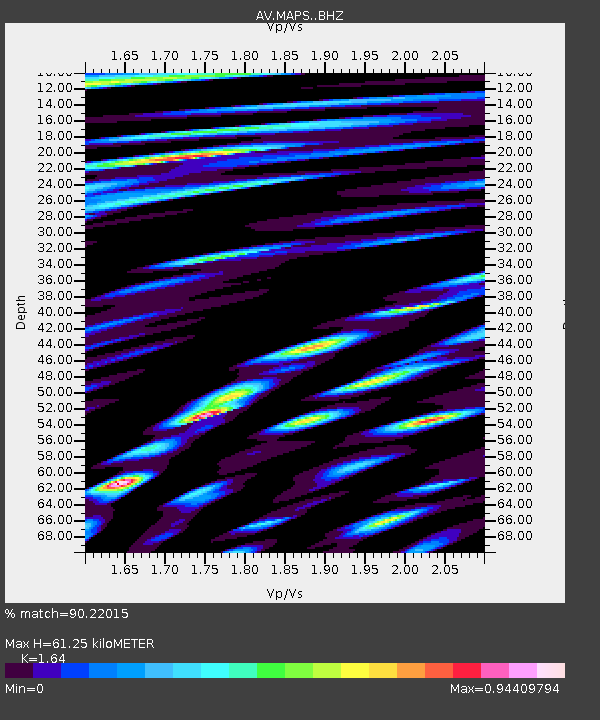
| Estimated Moho Depth: |
61.25 km |
| Estimated Crust Vp/Vs: |
1.64 |
| Assumed Crust Vp: |
3.943 km/s |
| Estimated Crust Vs: |
2.405 km/s |
| Estimated Crust Poisson's Ratio: |
0.20 |
|
| Radial Match: |
90.22015 % |
| Radial Bump: |
400 |
| Transverse Match: |
81.019936 % |
| Transverse Bump: |
400 |
| SOD ConfigId: |
13570011 |
| Insert Time: |
2019-04-29 02:31:12.342 +0000 |
| GWidth: |
2.5 |
| Max Bumps: |
400 |
| Tol: |
0.001 |
|
Signal To Noise
| Channel | StoN | STA | LTA |
| AV:MAPS: :BHZ:20171104T09:10:54.039998Z | 11.144332 | 4.9571127E-6 | 4.448102E-7 |
| AV:MAPS: :BHN:20171104T09:10:54.039998Z | 6.745579 | 1.8954966E-6 | 2.8099836E-7 |
| AV:MAPS: :BHE:20171104T09:10:54.039998Z | 5.1951556 | 1.9033918E-6 | 3.663782E-7 |
| Arrivals |
| Ps | 10 SECOND |
| PpPs | 40 SECOND |
| PsPs/PpSs | 50 SECOND |


