You are here: Home > Network List > AV - Alaska Volcano Observatory Stations List
> Station MNAT Nateekin Bay, Makushin Volcano, Alaska > Earthquake Result Viewer
MNAT Nateekin Bay, Makushin Volcano, Alaska - Earthquake Result Viewer
| Earthquake location: |
Tonga Islands |
| Earthquake latitude/longitude: |
-15.4/-173.2 |
| Earthquake time(UTC): |
2017/11/04 (308) 09:00:19 GMT |
| Earthquake Depth: |
10 km |
| Earthquake Magnitude: |
6.8 Mww |
| Earthquake Catalog/Contributor: |
NEIC PDE/us |
|
| Network: |
AV Alaska Volcano Observatory |
| Station: |
MNAT Nateekin Bay, Makushin Volcano, Alaska |
| Lat/Lon: |
53.88 N/166.69 W |
| Elevation: |
390 m |
|
| Distance: |
69.2 deg |
| Az: |
4.133 deg |
| Baz: |
186.744 deg |
| Ray Param: |
0.05581451 |
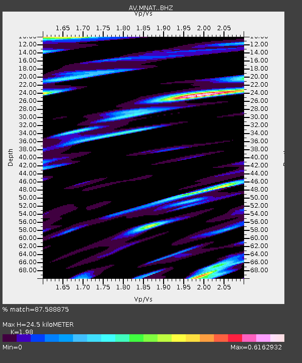
| Estimated Moho Depth: |
24.5 km |
| Estimated Crust Vp/Vs: |
1.98 |
| Assumed Crust Vp: |
3.943 km/s |
| Estimated Crust Vs: |
1.992 km/s |
| Estimated Crust Poisson's Ratio: |
0.33 |
|
| Radial Match: |
87.588875 % |
| Radial Bump: |
400 |
| Transverse Match: |
83.49974 % |
| Transverse Bump: |
400 |
| SOD ConfigId: |
13570011 |
| Insert Time: |
2019-04-29 02:31:13.485 +0000 |
| GWidth: |
2.5 |
| Max Bumps: |
400 |
| Tol: |
0.001 |
|

Signal To Noise
| Channel | StoN | STA | LTA |
| AV:MNAT: :BHZ:20171104T09:10:54.599019Z | 14.685367 | 4.4398253E-6 | 3.023299E-7 |
| AV:MNAT: :BHN:20171104T09:10:54.599019Z | 6.543587 | 2.0549783E-6 | 3.1404463E-7 |
| AV:MNAT: :BHE:20171104T09:10:54.599019Z | 2.0436559 | 8.6864276E-7 | 4.2504354E-7 |
| Arrivals |
| Ps | 6.2 SECOND |
| PpPs | 18 SECOND |
| PsPs/PpSs | 24 SECOND |


