You are here: Home > Network List > AV - Alaska Volcano Observatory Stations List
> Station MTBL Table Top, Makushin Volcano, Alaska > Earthquake Result Viewer
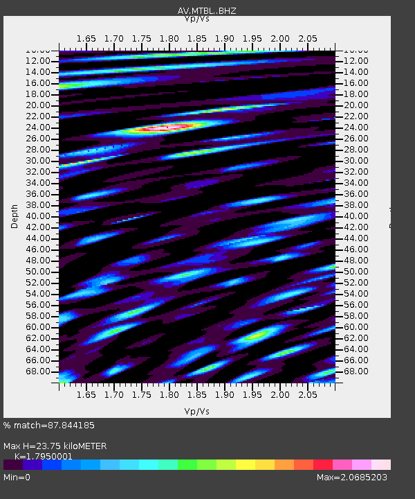
MTBL Table Top, Makushin Volcano, Alaska - Earthquake Result Viewer
| Earthquake location: |
Tonga Islands |
| Earthquake latitude/longitude: |
-15.4/-173.2 |
| Earthquake time(UTC): |
2017/11/04 (308) 09:00:19 GMT |
| Earthquake Depth: |
10 km |
| Earthquake Magnitude: |
6.8 Mww |
| Earthquake Catalog/Contributor: |
NEIC PDE/us |
|
| Network: |
AV Alaska Volcano Observatory |
| Station: |
MTBL Table Top, Makushin Volcano, Alaska |
| Lat/Lon: |
53.97 N/166.68 W |
| Elevation: |
810 m |
|
| Distance: |
69.3 deg |
| Az: |
4.125 deg |
| Baz: |
186.745 deg |
| Ray Param: |
0.05575829 |
| Estimated Moho Depth: |
23.75 km |
| Estimated Crust Vp/Vs: |
1.80 |
| Assumed Crust Vp: |
3.943 km/s |
| Estimated Crust Vs: |
2.197 km/s |
| Estimated Crust Poisson's Ratio: |
0.27 |
|
| Radial Match: |
87.844185 % |
| Radial Bump: |
400 |
| Transverse Match: |
89.00512 % |
| Transverse Bump: |
400 |
| SOD ConfigId: |
13570011 |
| Insert Time: |
2019-04-29 02:31:14.617 +0000 |
| GWidth: |
2.5 |
| Max Bumps: |
400 |
| Tol: |
0.001 |
|

Signal To Noise
| Channel | StoN | STA | LTA |
| AV:MTBL: :BHZ:20171104T09:10:55.120015Z | 17.646885 | 6.3707434E-6 | 3.6101233E-7 |
| AV:MTBL: :BHN:20171104T09:10:55.120015Z | 4.902797 | 3.9489532E-6 | 8.0544896E-7 |
| AV:MTBL: :BHE:20171104T09:10:55.120015Z | 4.544573 | 5.5209252E-6 | 1.2148392E-6 |
| Arrivals |
| Ps | 4.9 SECOND |
| PpPs | 17 SECOND |
| PsPs/PpSs | 21 SECOND |


