You are here: Home > Network List > AZ - ANZA Regional Network Stations List
> Station SMER AZ.SMER > Earthquake Result Viewer
SMER AZ.SMER - Earthquake Result Viewer
| Earthquake location: |
Tonga Islands |
| Earthquake latitude/longitude: |
-15.4/-173.2 |
| Earthquake time(UTC): |
2017/11/04 (308) 09:00:19 GMT |
| Earthquake Depth: |
10 km |
| Earthquake Magnitude: |
6.8 Mww |
| Earthquake Catalog/Contributor: |
NEIC PDE/us |
|
| Network: |
AZ ANZA Regional Network |
| Station: |
SMER AZ.SMER |
| Lat/Lon: |
33.46 N/117.17 W |
| Elevation: |
355 m |
|
| Distance: |
72.2 deg |
| Az: |
46.753 deg |
| Baz: |
237.203 deg |
| Ray Param: |
0.053831775 |
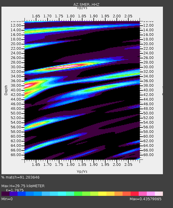
| Estimated Moho Depth: |
29.75 km |
| Estimated Crust Vp/Vs: |
1.77 |
| Assumed Crust Vp: |
6.264 km/s |
| Estimated Crust Vs: |
3.544 km/s |
| Estimated Crust Poisson's Ratio: |
0.26 |
|
| Radial Match: |
91.283646 % |
| Radial Bump: |
278 |
| Transverse Match: |
81.8669 % |
| Transverse Bump: |
346 |
| SOD ConfigId: |
13570011 |
| Insert Time: |
2019-04-29 02:31:43.850 +0000 |
| GWidth: |
2.5 |
| Max Bumps: |
400 |
| Tol: |
0.001 |
|
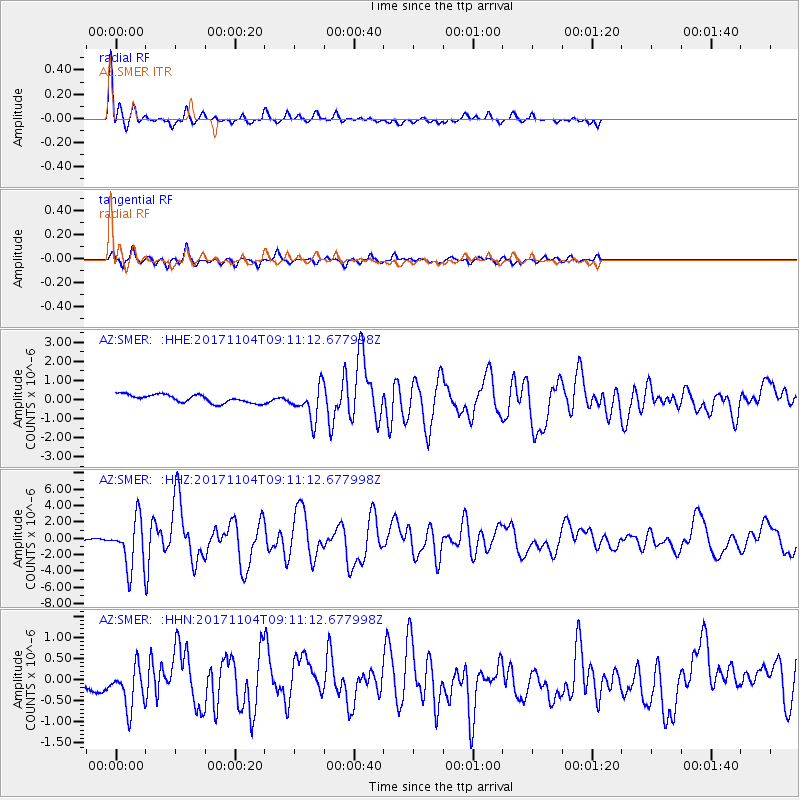
Signal To Noise
| Channel | StoN | STA | LTA |
| AZ:SMER: :HHZ:20171104T09:11:12.677998Z | 31.240635 | 3.029626E-6 | 9.69771E-8 |
| AZ:SMER: :HHN:20171104T09:11:12.677998Z | 3.081169 | 5.3301716E-7 | 1.7299188E-7 |
| AZ:SMER: :HHE:20171104T09:11:12.677998Z | 4.323054 | 8.9319434E-7 | 2.0661187E-7 |
| Arrivals |
| Ps | 3.8 SECOND |
| PpPs | 13 SECOND |
| PsPs/PpSs | 16 SECOND |


