You are here: Home > Network List > CI - Caltech Regional Seismic Network Stations List
> Station BBR Big Bear Solar Observatory > Earthquake Result Viewer
BBR Big Bear Solar Observatory - Earthquake Result Viewer
| Earthquake location: |
Peru-Ecuador Border Region |
| Earthquake latitude/longitude: |
-2.3/-77.8 |
| Earthquake time(UTC): |
2007/11/16 (320) 03:13:00 GMT |
| Earthquake Depth: |
123 km |
| Earthquake Magnitude: |
6.3 MB, 6.8 MW, 6.7 MW |
| Earthquake Catalog/Contributor: |
WHDF/NEIC |
|
| Network: |
CI Caltech Regional Seismic Network |
| Station: |
BBR Big Bear Solar Observatory |
| Lat/Lon: |
34.26 N/116.92 W |
| Elevation: |
2069 m |
|
| Distance: |
51.7 deg |
| Az: |
318.284 deg |
| Baz: |
126.601 deg |
| Ray Param: |
0.066839546 |
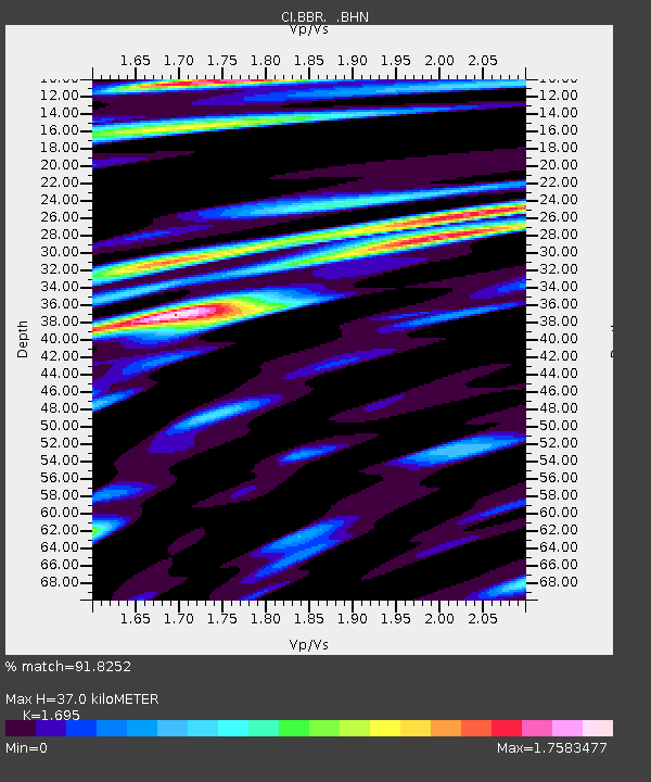
| Estimated Moho Depth: |
37.0 km |
| Estimated Crust Vp/Vs: |
1.70 |
| Assumed Crust Vp: |
6.276 km/s |
| Estimated Crust Vs: |
3.703 km/s |
| Estimated Crust Poisson's Ratio: |
0.23 |
|
| Radial Match: |
91.8252 % |
| Radial Bump: |
400 |
| Transverse Match: |
85.756935 % |
| Transverse Bump: |
400 |
| SOD ConfigId: |
2564 |
| Insert Time: |
2010-02-26 01:35:12.658 +0000 |
| GWidth: |
2.5 |
| Max Bumps: |
400 |
| Tol: |
0.001 |
|

Signal To Noise
| Channel | StoN | STA | LTA |
| CI:BBR: :BHN:20071116T03:21:23.988011Z | 4.9421735 | 1.0008649E-6 | 2.0251512E-7 |
| CI:BBR: :BHE:20071116T03:21:23.988011Z | 5.5880065 | 9.049417E-7 | 1.6194356E-7 |
| CI:BBR: :BHZ:20071116T03:21:23.988011Z | 17.554895 | 2.0024438E-6 | 1.1406753E-7 |
| Arrivals |
| Ps | 4.3 SECOND |
| PpPs | 15 SECOND |
| PsPs/PpSs | 19 SECOND |


