You are here: Home > Network List > C1 - Red Sismologica Nacional Stations List
> Station MT12 Pirque > Earthquake Result Viewer
MT12 Pirque - Earthquake Result Viewer
| Earthquake location: |
Tonga Islands |
| Earthquake latitude/longitude: |
-15.4/-173.2 |
| Earthquake time(UTC): |
2017/11/04 (308) 09:00:19 GMT |
| Earthquake Depth: |
10 km |
| Earthquake Magnitude: |
6.8 Mww |
| Earthquake Catalog/Contributor: |
NEIC PDE/us |
|
| Network: |
C1 Red Sismologica Nacional |
| Station: |
MT12 Pirque |
| Lat/Lon: |
33.73 S/70.55 W |
| Elevation: |
727 m |
|
| Distance: |
91.8 deg |
| Az: |
125.566 deg |
| Baz: |
250.339 deg |
| Ray Param: |
0.041559514 |
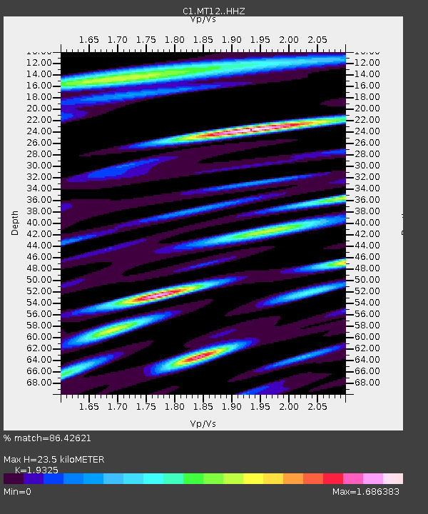
| Estimated Moho Depth: |
23.5 km |
| Estimated Crust Vp/Vs: |
1.93 |
| Assumed Crust Vp: |
6.481 km/s |
| Estimated Crust Vs: |
3.354 km/s |
| Estimated Crust Poisson's Ratio: |
0.32 |
|
| Radial Match: |
86.42621 % |
| Radial Bump: |
400 |
| Transverse Match: |
81.07586 % |
| Transverse Bump: |
400 |
| SOD ConfigId: |
13570011 |
| Insert Time: |
2019-04-29 02:32:24.565 +0000 |
| GWidth: |
2.5 |
| Max Bumps: |
400 |
| Tol: |
0.001 |
|

Signal To Noise
| Channel | StoN | STA | LTA |
| C1:MT12: :HHZ:20171104T09:12:55.537983Z | 11.5976515 | 2.4782196E-6 | 2.1368288E-7 |
| C1:MT12: :HHN:20171104T09:12:55.537983Z | 1.0382527 | 2.6708784E-7 | 2.5724742E-7 |
| C1:MT12: :HHE:20171104T09:12:55.537983Z | 3.423173 | 9.804238E-7 | 2.8640792E-7 |
| Arrivals |
| Ps | 3.4 SECOND |
| PpPs | 10 SECOND |
| PsPs/PpSs | 14 SECOND |


