You are here: Home > Network List > CI - Caltech Regional Seismic Network Stations List
> Station BC3 Big Chuckawalla Mtns, Desert Center, CA, USA > Earthquake Result Viewer
BC3 Big Chuckawalla Mtns, Desert Center, CA, USA - Earthquake Result Viewer

| Earthquake location: |
Tonga Islands |
| Earthquake latitude/longitude: |
-15.4/-173.2 |
| Earthquake time(UTC): |
2017/11/04 (308) 09:00:19 GMT |
| Earthquake Depth: |
10 km |
| Earthquake Magnitude: |
6.8 Mww |
| Earthquake Catalog/Contributor: |
NEIC PDE/us |
|
| Network: |
CI Caltech Regional Seismic Network |
| Station: |
BC3 Big Chuckawalla Mtns, Desert Center, CA, USA |
| Lat/Lon: |
33.66 N/115.45 W |
| Elevation: |
1137 m |
|
| Distance: |
73.5 deg |
| Az: |
47.379 deg |
| Baz: |
238.332 deg |
| Ray Param: |
0.052963547 |
| Estimated Moho Depth: |
20.0 km |
| Estimated Crust Vp/Vs: |
1.93 |
| Assumed Crust Vp: |
6.155 km/s |
| Estimated Crust Vs: |
3.193 km/s |
| Estimated Crust Poisson's Ratio: |
0.32 |
|
| Radial Match: |
92.85451 % |
| Radial Bump: |
371 |
| Transverse Match: |
83.26112 % |
| Transverse Bump: |
400 |
| SOD ConfigId: |
13570011 |
| Insert Time: |
2019-04-29 02:32:46.630 +0000 |
| GWidth: |
2.5 |
| Max Bumps: |
400 |
| Tol: |
0.001 |
|
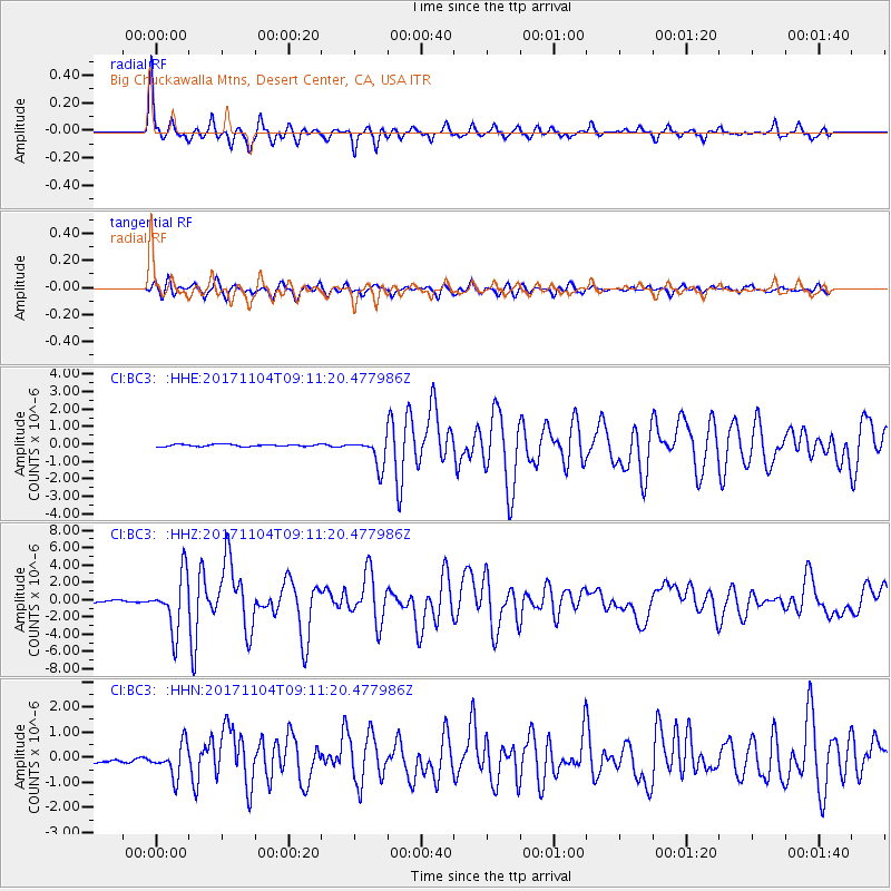
Signal To Noise
| Channel | StoN | STA | LTA |
| CI:BC3: :HHZ:20171104T09:11:20.477986Z | 21.08767 | 3.177774E-6 | 1.5069347E-7 |
| CI:BC3: :HHN:20171104T09:11:20.477986Z | 5.2807255 | 6.344265E-7 | 1.2014002E-7 |
| CI:BC3: :HHE:20171104T09:11:20.477986Z | 17.90631 | 1.076392E-6 | 6.011244E-8 |
| Arrivals |
| Ps | 3.1 SECOND |
| PpPs | 9.2 SECOND |
| PsPs/PpSs | 12 SECOND |


