You are here: Home > Network List > CI - Caltech Regional Seismic Network Stations List
> Station SWS Sam W. Stewart, Westmorland, CA, USA > Earthquake Result Viewer
SWS Sam W. Stewart, Westmorland, CA, USA - Earthquake Result Viewer
| Earthquake location: |
Tonga Islands |
| Earthquake latitude/longitude: |
-15.4/-173.2 |
| Earthquake time(UTC): |
2017/11/04 (308) 09:00:19 GMT |
| Earthquake Depth: |
10 km |
| Earthquake Magnitude: |
6.8 Mww |
| Earthquake Catalog/Contributor: |
NEIC PDE/us |
|
| Network: |
CI Caltech Regional Seismic Network |
| Station: |
SWS Sam W. Stewart, Westmorland, CA, USA |
| Lat/Lon: |
32.94 N/115.80 W |
| Elevation: |
140 m |
|
| Distance: |
72.9 deg |
| Az: |
47.855 deg |
| Baz: |
238.283 deg |
| Ray Param: |
0.053369924 |
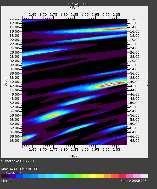
| Estimated Moho Depth: |
41.0 km |
| Estimated Crust Vp/Vs: |
2.02 |
| Assumed Crust Vp: |
6.155 km/s |
| Estimated Crust Vs: |
3.043 km/s |
| Estimated Crust Poisson's Ratio: |
0.34 |
|
| Radial Match: |
90.64708 % |
| Radial Bump: |
400 |
| Transverse Match: |
91.98828 % |
| Transverse Bump: |
400 |
| SOD ConfigId: |
13570011 |
| Insert Time: |
2019-04-29 02:33:27.150 +0000 |
| GWidth: |
2.5 |
| Max Bumps: |
400 |
| Tol: |
0.001 |
|

Signal To Noise
| Channel | StoN | STA | LTA |
| CI:SWS: :HHZ:20171104T09:11:16.828022Z | 18.101149 | 2.7980493E-6 | 1.5457854E-7 |
| CI:SWS: :HHN:20171104T09:11:16.828022Z | 9.926734 | 1.4013867E-6 | 1.4117299E-7 |
| CI:SWS: :HHE:20171104T09:11:16.828022Z | 5.3293 | 1.1796739E-6 | 2.2135625E-7 |
| Arrivals |
| Ps | 7.0 SECOND |
| PpPs | 20 SECOND |
| PsPs/PpSs | 27 SECOND |


