You are here: Home > Network List > JP - Japan Meteorological Agency Seismic Network Stations List
> Station JKA Kamikawa Asahi > Earthquake Result Viewer
JKA Kamikawa Asahi - Earthquake Result Viewer
| Earthquake location: |
Tonga Islands |
| Earthquake latitude/longitude: |
-15.4/-173.2 |
| Earthquake time(UTC): |
2017/11/04 (308) 09:00:19 GMT |
| Earthquake Depth: |
10 km |
| Earthquake Magnitude: |
6.8 Mww |
| Earthquake Catalog/Contributor: |
NEIC PDE/us |
|
| Network: |
JP Japan Meteorological Agency Seismic Network |
| Station: |
JKA Kamikawa Asahi |
| Lat/Lon: |
41.12 N/142.59 E |
| Elevation: |
220 m |
|
| Distance: |
69.5 deg |
| Az: |
325.79 deg |
| Baz: |
134.117 deg |
| Ray Param: |
0.055608083 |
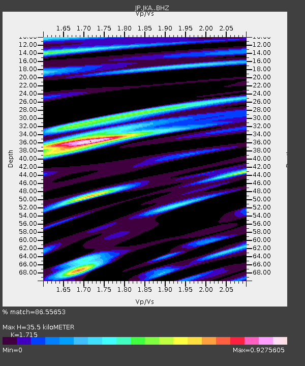
| Estimated Moho Depth: |
35.5 km |
| Estimated Crust Vp/Vs: |
1.72 |
| Assumed Crust Vp: |
6.183 km/s |
| Estimated Crust Vs: |
3.605 km/s |
| Estimated Crust Poisson's Ratio: |
0.24 |
|
| Radial Match: |
86.55653 % |
| Radial Bump: |
400 |
| Transverse Match: |
69.79233 % |
| Transverse Bump: |
400 |
| SOD ConfigId: |
13570011 |
| Insert Time: |
2019-04-29 02:34:50.712 +0000 |
| GWidth: |
2.5 |
| Max Bumps: |
400 |
| Tol: |
0.001 |
|

Signal To Noise
| Channel | StoN | STA | LTA |
| JP:JKA: :BHZ:20171104T09:11:09.550007Z | 1.2464414 | 2.3816737E-7 | 1.9107789E-7 |
| JP:JKA: :BHN:20171104T09:11:09.550007Z | 0.9165863 | 2.2502557E-7 | 2.4550397E-7 |
| JP:JKA: :BHE:20171104T09:11:09.550007Z | 1.149285 | 2.457077E-7 | 2.1379181E-7 |
| Arrivals |
| Ps | 4.3 SECOND |
| PpPs | 15 SECOND |
| PsPs/PpSs | 19 SECOND |


