You are here: Home > Network List > TA - USArray Transportable Network (new EarthScope stations) Stations List
> Station P14A Drum Mountains (BLM), Topaz, UT, USA > Earthquake Result Viewer
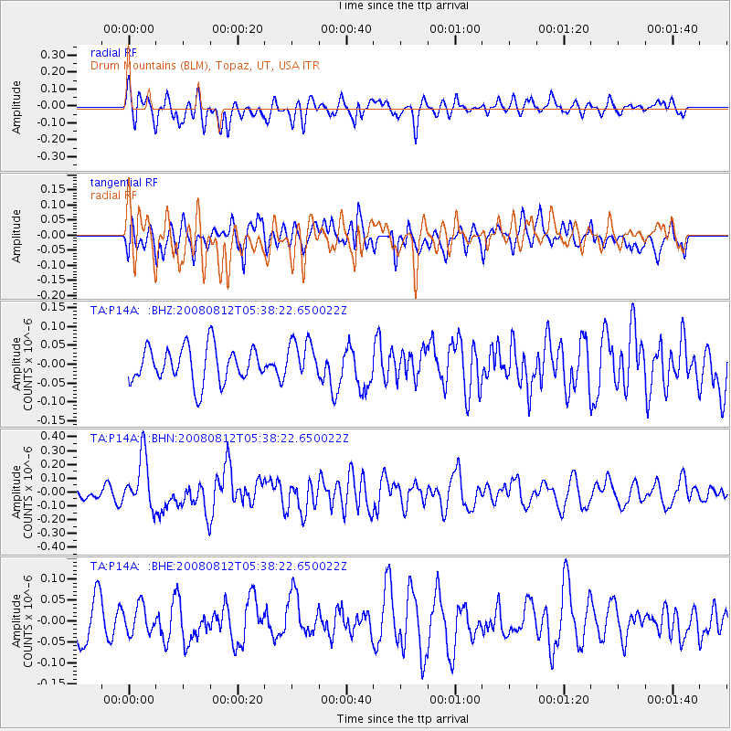
P14A Drum Mountains (BLM), Topaz, UT, USA - Earthquake Result Viewer
*The percent match for this event was below the threshold and hence no stack was calculated.
| Earthquake location: |
Santa Cruz Islands |
| Earthquake latitude/longitude: |
-11.4/166.2 |
| Earthquake time(UTC): |
2008/08/12 (225) 05:25:57 GMT |
| Earthquake Depth: |
38 km |
| Earthquake Magnitude: |
5.9 MW, 5.4 MS, 5.2 MB, 5.8 MW |
| Earthquake Catalog/Contributor: |
WHDF/NEIC |
|
| Network: |
TA USArray Transportable Network (new EarthScope stations) |
| Station: |
P14A Drum Mountains (BLM), Topaz, UT, USA |
| Lat/Lon: |
39.59 N/113.07 W |
| Elevation: |
1784 m |
|
| Distance: |
90.1 deg |
| Az: |
49.691 deg |
| Baz: |
255.361 deg |
| Ray Param: |
$rayparam |
*The percent match for this event was below the threshold and hence was not used in the summary stack. |
|
| Radial Match: |
51.843143 % |
| Radial Bump: |
389 |
| Transverse Match: |
46.47762 % |
| Transverse Bump: |
400 |
| SOD ConfigId: |
2504 |
| Insert Time: |
2010-03-06 05:55:11.138 +0000 |
| GWidth: |
2.5 |
| Max Bumps: |
400 |
| Tol: |
0.001 |
|
Signal To Noise
| Channel | StoN | STA | LTA |
| TA:P14A: :BHN:20080812T05:38:22.650022Z | 3.503962 | 1.9318372E-7 | 5.5132936E-8 |
| TA:P14A: :BHE:20080812T05:38:22.650022Z | 0.63989943 | 3.320905E-8 | 5.18973E-8 |
| TA:P14A: :BHZ:20080812T05:38:22.650022Z | 1.0710006 | 5.024265E-8 | 4.6911882E-8 |
| Arrivals |
| Ps | |
| PpPs | |
| PsPs/PpSs | |


