You are here: Home > Network List > N4 - Central and EAstern US Network Stations List
> Station X48A Hartselle, AL, USA > Earthquake Result Viewer
X48A Hartselle, AL, USA - Earthquake Result Viewer
| Earthquake location: |
Tonga Islands |
| Earthquake latitude/longitude: |
-15.4/-173.2 |
| Earthquake time(UTC): |
2017/11/04 (308) 09:00:19 GMT |
| Earthquake Depth: |
10 km |
| Earthquake Magnitude: |
6.8 Mww |
| Earthquake Catalog/Contributor: |
NEIC PDE/us |
|
| Network: |
N4 Central and EAstern US Network |
| Station: |
X48A Hartselle, AL, USA |
| Lat/Lon: |
34.45 N/87.05 W |
| Elevation: |
180 m |
|
| Distance: |
95.5 deg |
| Az: |
55.922 deg |
| Baz: |
255.233 deg |
| Ray Param: |
0.040778663 |
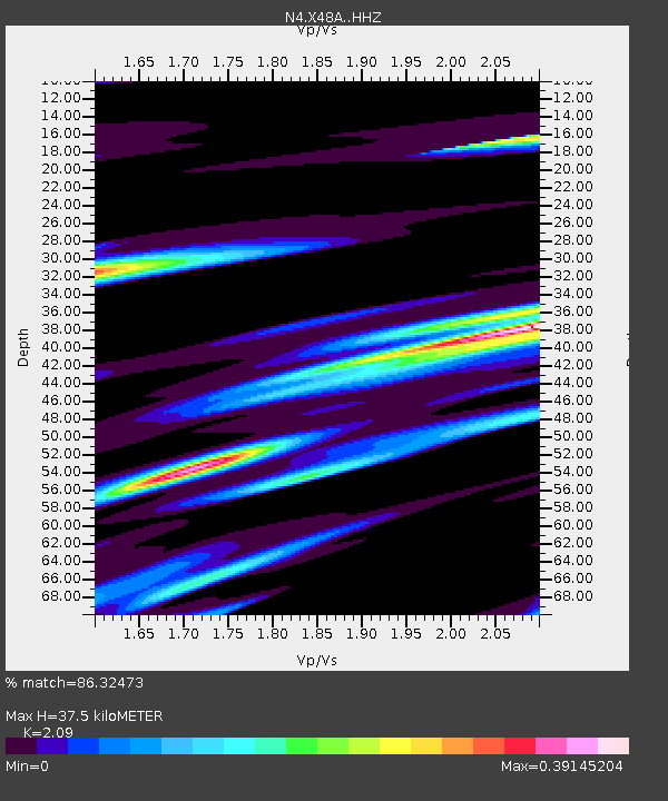
| Estimated Moho Depth: |
37.5 km |
| Estimated Crust Vp/Vs: |
2.09 |
| Assumed Crust Vp: |
6.476 km/s |
| Estimated Crust Vs: |
3.099 km/s |
| Estimated Crust Poisson's Ratio: |
0.35 |
|
| Radial Match: |
86.32473 % |
| Radial Bump: |
319 |
| Transverse Match: |
70.12521 % |
| Transverse Bump: |
400 |
| SOD ConfigId: |
13570011 |
| Insert Time: |
2019-04-29 02:35:48.601 +0000 |
| GWidth: |
2.5 |
| Max Bumps: |
400 |
| Tol: |
0.001 |
|

Signal To Noise
| Channel | StoN | STA | LTA |
| N4:X48A: :HHZ:20171104T09:13:12.180012Z | 8.217615 | 7.958598E-7 | 9.684803E-8 |
| N4:X48A: :HHN:20171104T09:13:12.180012Z | 2.3857327 | 1.6551371E-7 | 6.937647E-8 |
| N4:X48A: :HHE:20171104T09:13:12.180012Z | 3.2368817 | 2.8206006E-7 | 8.713943E-8 |
| Arrivals |
| Ps | 6.4 SECOND |
| PpPs | 18 SECOND |
| PsPs/PpSs | 24 SECOND |


