You are here: Home > Network List > CI - Caltech Regional Seismic Network Stations List
> Station BBR Big Bear Solar Observatory > Earthquake Result Viewer
BBR Big Bear Solar Observatory - Earthquake Result Viewer
| Earthquake location: |
Near West Coast Of Colombia |
| Earthquake latitude/longitude: |
3.0/-78.0 |
| Earthquake time(UTC): |
2007/09/10 (253) 01:49:14 GMT |
| Earthquake Depth: |
31 km |
| Earthquake Magnitude: |
6.1 MB, 6.7 MS, 6.8 MW |
| Earthquake Catalog/Contributor: |
WHDF/NEIC |
|
| Network: |
CI Caltech Regional Seismic Network |
| Station: |
BBR Big Bear Solar Observatory |
| Lat/Lon: |
34.26 N/116.92 W |
| Elevation: |
2069 m |
|
| Distance: |
47.8 deg |
| Az: |
315.31 deg |
| Baz: |
122.006 deg |
| Ray Param: |
0.06972563 |
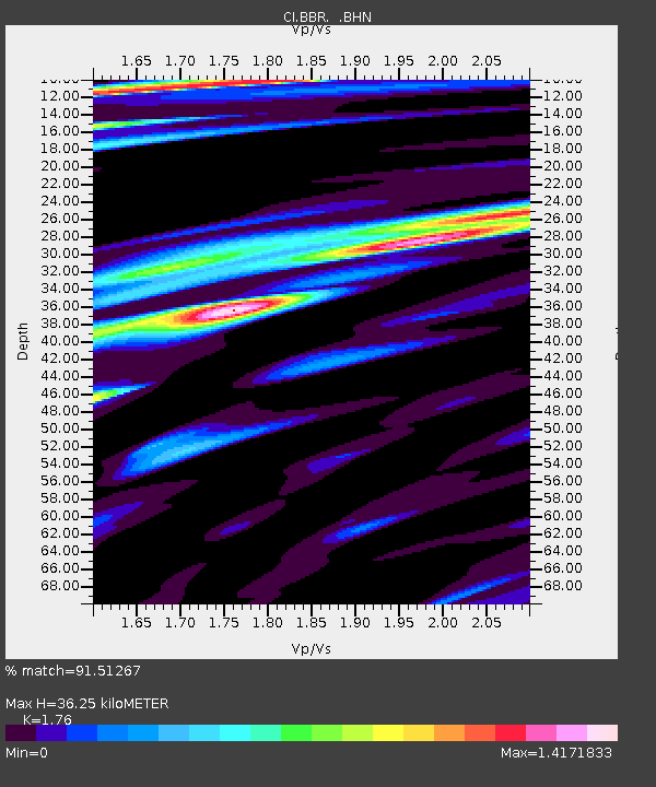
| Estimated Moho Depth: |
36.25 km |
| Estimated Crust Vp/Vs: |
1.76 |
| Assumed Crust Vp: |
6.276 km/s |
| Estimated Crust Vs: |
3.566 km/s |
| Estimated Crust Poisson's Ratio: |
0.26 |
|
| Radial Match: |
91.51267 % |
| Radial Bump: |
400 |
| Transverse Match: |
84.742 % |
| Transverse Bump: |
400 |
| SOD ConfigId: |
2564 |
| Insert Time: |
2010-02-26 01:35:24.091 +0000 |
| GWidth: |
2.5 |
| Max Bumps: |
400 |
| Tol: |
0.001 |
|
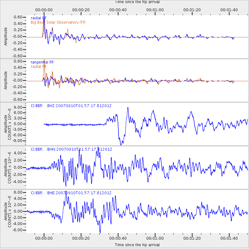
Signal To Noise
| Channel | StoN | STA | LTA |
| CI:BBR: :BHN:20070910T01:57:17.81201Z | 2.090959 | 4.2221404E-7 | 2.0192363E-7 |
| CI:BBR: :BHE:20070910T01:57:17.81201Z | 3.6914635 | 5.392101E-7 | 1.4606947E-7 |
| CI:BBR: :BHZ:20070910T01:57:17.81201Z | 5.9249196 | 1.0761806E-6 | 1.8163632E-7 |
| Arrivals |
| Ps | 4.7 SECOND |
| PpPs | 15 SECOND |
| PsPs/PpSs | 20 SECOND |


