You are here: Home > Network List > TA - USArray Transportable Network (new EarthScope stations) Stations List
> Station 833A Chaparral WMA, Artesia Wells, TX, USA > Earthquake Result Viewer
833A Chaparral WMA, Artesia Wells, TX, USA - Earthquake Result Viewer

| Earthquake location: |
Tonga Islands |
| Earthquake latitude/longitude: |
-15.4/-173.2 |
| Earthquake time(UTC): |
2017/11/04 (308) 09:00:19 GMT |
| Earthquake Depth: |
10 km |
| Earthquake Magnitude: |
6.8 Mww |
| Earthquake Catalog/Contributor: |
NEIC PDE/us |
|
| Network: |
TA USArray Transportable Network (new EarthScope stations) |
| Station: |
833A Chaparral WMA, Artesia Wells, TX, USA |
| Lat/Lon: |
28.32 N/99.39 W |
| Elevation: |
171 m |
|
| Distance: |
83.5 deg |
| Az: |
58.445 deg |
| Baz: |
248.828 deg |
| Ray Param: |
0.046123926 |
| Estimated Moho Depth: |
14.0 km |
| Estimated Crust Vp/Vs: |
1.78 |
| Assumed Crust Vp: |
6.347 km/s |
| Estimated Crust Vs: |
3.561 km/s |
| Estimated Crust Poisson's Ratio: |
0.27 |
|
| Radial Match: |
85.86781 % |
| Radial Bump: |
400 |
| Transverse Match: |
83.19411 % |
| Transverse Bump: |
400 |
| SOD ConfigId: |
13570011 |
| Insert Time: |
2019-04-29 02:38:15.610 +0000 |
| GWidth: |
2.5 |
| Max Bumps: |
400 |
| Tol: |
0.001 |
|
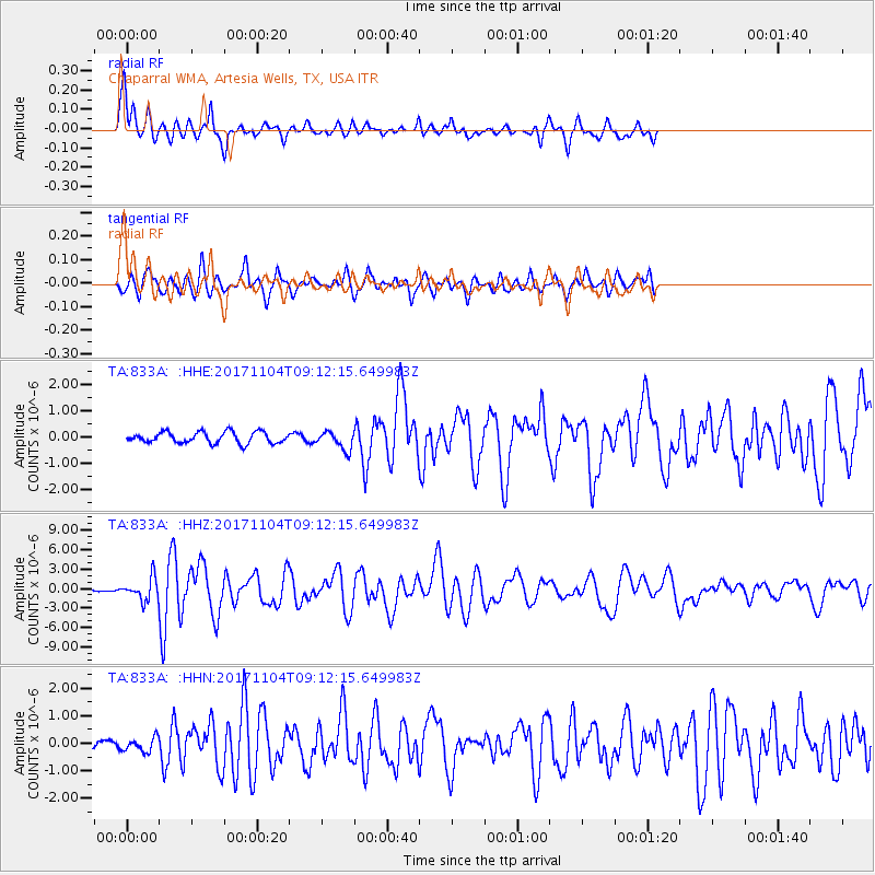
Signal To Noise
| Channel | StoN | STA | LTA |
| TA:833A: :HHZ:20171104T09:12:15.649983Z | 15.486506 | 1.6970586E-6 | 1.0958305E-7 |
| TA:833A: :HHN:20171104T09:12:15.649983Z | 1.9132677 | 2.4879466E-7 | 1.3003651E-7 |
| TA:833A: :HHE:20171104T09:12:15.649983Z | 1.8467222 | 3.9632334E-7 | 2.1460906E-7 |
| Arrivals |
| Ps | 1.8 SECOND |
| PpPs | 6.0 SECOND |
| PsPs/PpSs | 7.8 SECOND |


