You are here: Home > Network List > WY - Yellowstone Wyoming Seismic Network Stations List
> Station YHH Holmes Hill, YNP, WY, USA > Earthquake Result Viewer
YHH Holmes Hill, YNP, WY, USA - Earthquake Result Viewer
| Earthquake location: |
Fox Islands, Aleutian Islands |
| Earthquake latitude/longitude: |
52.2/-168.7 |
| Earthquake time(UTC): |
2016/03/27 (087) 18:01:30 GMT |
| Earthquake Depth: |
16 km |
| Earthquake Magnitude: |
5.7 MWB |
| Earthquake Catalog/Contributor: |
NEIC PDE/NEIC COMCAT |
|
| Network: |
WY Yellowstone Wyoming Seismic Network |
| Station: |
YHH Holmes Hill, YNP, WY, USA |
| Lat/Lon: |
44.79 N/110.85 W |
| Elevation: |
2717 m |
|
| Distance: |
38.2 deg |
| Az: |
77.475 deg |
| Baz: |
302.433 deg |
| Ray Param: |
0.07570729 |
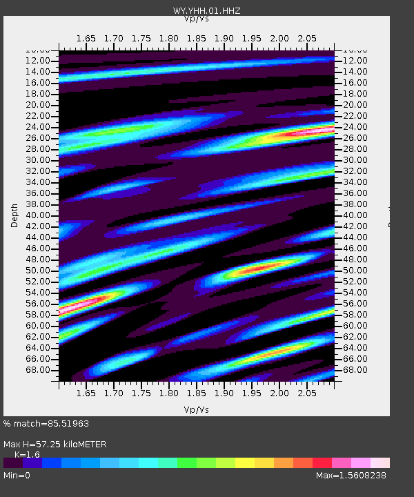
| Estimated Moho Depth: |
57.25 km |
| Estimated Crust Vp/Vs: |
1.60 |
| Assumed Crust Vp: |
6.35 km/s |
| Estimated Crust Vs: |
3.969 km/s |
| Estimated Crust Poisson's Ratio: |
0.18 |
|
| Radial Match: |
85.51963 % |
| Radial Bump: |
400 |
| Transverse Match: |
64.47822 % |
| Transverse Bump: |
400 |
| SOD ConfigId: |
1475611 |
| Insert Time: |
2016-04-11 16:31:41.889 +0000 |
| GWidth: |
2.5 |
| Max Bumps: |
400 |
| Tol: |
0.001 |
|
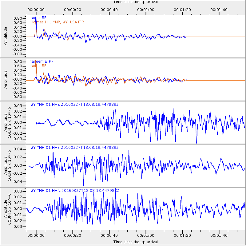
Signal To Noise
| Channel | StoN | STA | LTA |
| WY:YHH:01:HHZ:20160327T18:08:18.447988Z | 2.953394 | 6.775553E-9 | 2.294158E-9 |
| WY:YHH:01:HHN:20160327T18:08:18.447988Z | 1.6508317 | 2.6567788E-9 | 1.6093578E-9 |
| WY:YHH:01:HHE:20160327T18:08:18.447988Z | 1.0479504 | 3.1277385E-9 | 2.9846248E-9 |
| Arrivals |
| Ps | 5.9 SECOND |
| PpPs | 22 SECOND |
| PsPs/PpSs | 28 SECOND |


