You are here: Home > Network List > TA - USArray Transportable Network (new EarthScope stations) Stations List
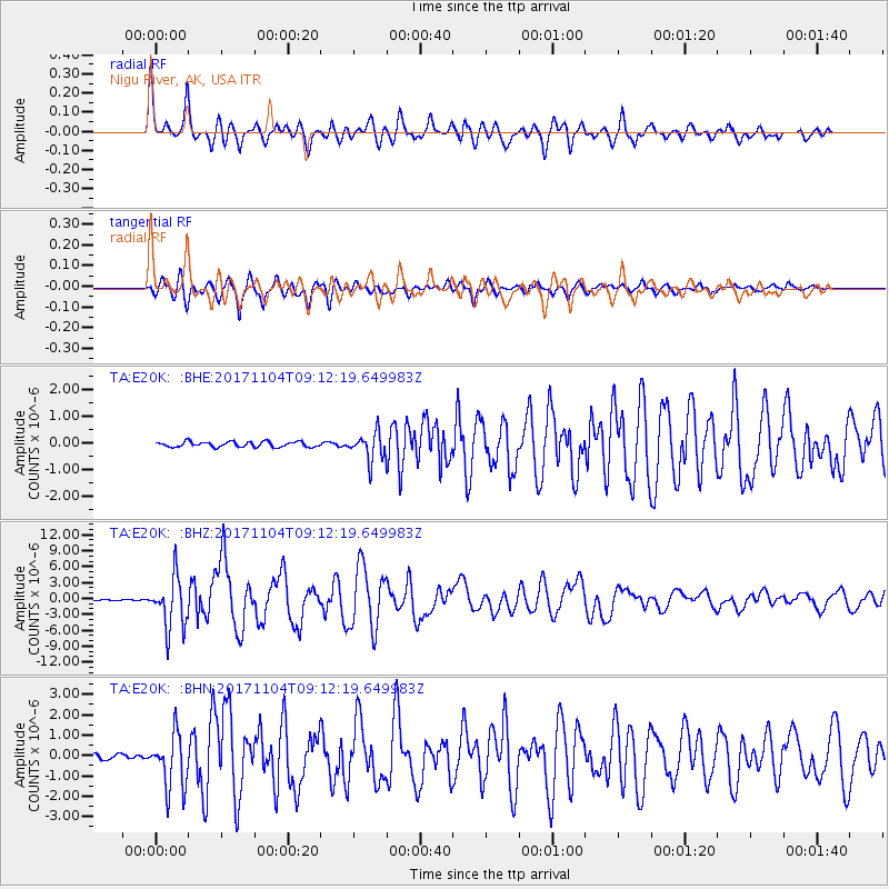
> Station E20K Nigu River, AK, USA > Earthquake Result Viewer
E20K Nigu River, AK, USA - Earthquake Result Viewer
| Earthquake location: |
Tonga Islands |
| Earthquake latitude/longitude: |
-15.4/-173.2 |
| Earthquake time(UTC): |
2017/11/04 (308) 09:00:19 GMT |
| Earthquake Depth: |
10 km |
| Earthquake Magnitude: |
6.8 Mww |
| Earthquake Catalog/Contributor: |
NEIC PDE/us |
|
| Network: |
TA USArray Transportable Network (new EarthScope stations) |
| Station: |
E20K Nigu River, AK, USA |
| Lat/Lon: |
68.26 N/156.19 W |
| Elevation: |
866 m |
|
| Distance: |
84.3 deg |
| Az: |
6.296 deg |
| Baz: |
196.497 deg |
| Ray Param: |
0.045587208 |
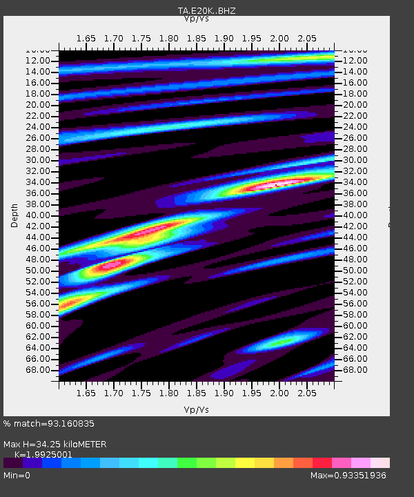
| Estimated Moho Depth: |
34.25 km |
| Estimated Crust Vp/Vs: |
1.99 |
| Assumed Crust Vp: |
6.221 km/s |
| Estimated Crust Vs: |
3.122 km/s |
| Estimated Crust Poisson's Ratio: |
0.33 |
|
| Radial Match: |
93.160835 % |
| Radial Bump: |
400 |
| Transverse Match: |
94.57761 % |
| Transverse Bump: |
400 |
| SOD ConfigId: |
13570011 |
| Insert Time: |
2019-04-29 02:38:41.800 +0000 |
| GWidth: |
2.5 |
| Max Bumps: |
400 |
| Tol: |
0.001 |
|
Signal To Noise
| Channel | StoN | STA | LTA |
| TA:E20K: :BHZ:20171104T09:12:19.649983Z | 40.337654 | 4.8487764E-6 | 1.2020472E-7 |
| TA:E20K: :BHN:20171104T09:12:19.649983Z | 13.729689 | 1.3380971E-6 | 9.746013E-8 |
| TA:E20K: :BHE:20171104T09:12:19.649983Z | 5.8430243 | 5.828054E-7 | 9.974379E-8 |
| Arrivals |
| Ps | 5.6 SECOND |
| PpPs | 16 SECOND |
| PsPs/PpSs | 22 SECOND |


