You are here: Home > Network List > TA - USArray Transportable Network (new EarthScope stations) Stations List
> Station E28M Babbage River, YT, CAN > Earthquake Result Viewer
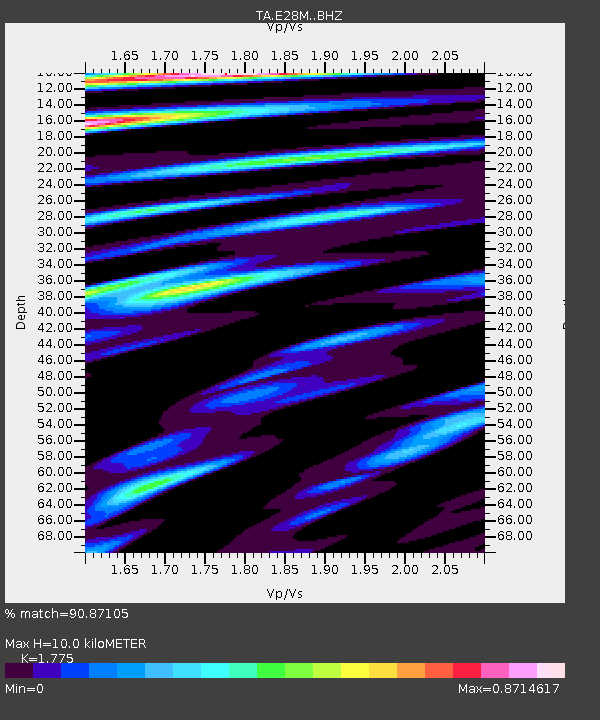
E28M Babbage River, YT, CAN - Earthquake Result Viewer
| Earthquake location: |
Tonga Islands |
| Earthquake latitude/longitude: |
-15.4/-173.2 |
| Earthquake time(UTC): |
2017/11/04 (308) 09:00:19 GMT |
| Earthquake Depth: |
10 km |
| Earthquake Magnitude: |
6.8 Mww |
| Earthquake Catalog/Contributor: |
NEIC PDE/us |
|
| Network: |
TA USArray Transportable Network (new EarthScope stations) |
| Station: |
E28M Babbage River, YT, CAN |
| Lat/Lon: |
68.60 N/139.53 W |
| Elevation: |
474 m |
|
| Distance: |
87.1 deg |
| Az: |
11.757 deg |
| Baz: |
212.393 deg |
| Ray Param: |
0.043532208 |
| Estimated Moho Depth: |
10.0 km |
| Estimated Crust Vp/Vs: |
1.77 |
| Assumed Crust Vp: |
6.316 km/s |
| Estimated Crust Vs: |
3.558 km/s |
| Estimated Crust Poisson's Ratio: |
0.27 |
|
| Radial Match: |
90.87105 % |
| Radial Bump: |
400 |
| Transverse Match: |
90.93899 % |
| Transverse Bump: |
400 |
| SOD ConfigId: |
13570011 |
| Insert Time: |
2019-04-29 02:38:47.496 +0000 |
| GWidth: |
2.5 |
| Max Bumps: |
400 |
| Tol: |
0.001 |
|

Signal To Noise
| Channel | StoN | STA | LTA |
| TA:E28M: :BHZ:20171104T09:12:33.774983Z | 13.615481 | 2.8039872E-6 | 2.059411E-7 |
| TA:E28M: :BHN:20171104T09:12:33.774983Z | 4.124003 | 6.9848704E-7 | 1.6937113E-7 |
| TA:E28M: :BHE:20171104T09:12:33.774983Z | 2.4285119 | 3.5967946E-7 | 1.4810693E-7 |
| Arrivals |
| Ps | 1.3 SECOND |
| PpPs | 4.3 SECOND |
| PsPs/PpSs | 5.6 SECOND |


